Tracing the Visitor's Eye
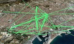
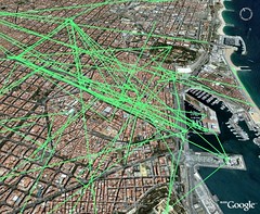
Posted: December 13th, 2006 | 4 Comments »In continuation of my exploration of Flickr geotagged images, I produced the “traces” left in Flickr by tourists and citizens of Barcelona based on around 4000 images taken between october 2006 until now. A trace consists in an ordered set of geotagged images taken by one person in one day. The data and visualizations remain brut, but there might be a potential to define and confirm patterns of how tourists navigate the urban space (e.g. the elephant path along the Rambla, people do not walk to Gaudi’s Sagrada Familia). The maps do not carry the sense of time yet to highlight when and where the traces start and end.

Related to Visualizing the Visitor’s Eye, Mental map of London and Tag Maps: Visualizing the Crowd’s “Mental Map” Using Flickr Geotagged Images


Fabien, great idea. ¿Cómo has hecho? ¿Hay avance en el concepto? Tengo interés personal. Vivo en Barcelona y estoy pensando en hacer una obra de arte que conecta google earth con fotos de Barcelona. La idea por la obra viene de un cuadro en un museo en Grenoble, Francia.
http://www.visualcomplexity.com/vc/project_details.cfm?id=404&index=404&domain= fue el link que me llevo aquí.
Paul
[...] But why just post the same ad for everyone to see? Why not use an individual viewer’s line of sight as they travel as a "channel" into which to project ads and messages where blank space exists? Fabien’s recent post, illustrated here, shows the "traces" left by Flickr photographers as they transit Barcelona. Where his heat maps showed the locations of single images, the traces follow the path the photographer takes through the city, or his visual corridor, if you will. [...]
[...] Fabien Girardin Institution: Pompeu Fabra University – Barcelona, Spain Year: 2006 URL: http://tinyurl.com/ybadhx Project Description: Fabien Girardin is a Ph.D. student in Computer Science and Digital Communication at the Interactive Technology Group at the Pompeu Fabra University in Barcelona, Spain. His current investigation explores the people perception of discrepencies in the context of collaboration supported by mobile and ubiquitous environments. [...]
[...] link « World’s biggest drawing created with the help of GPS and DHL Simulação Inicial » [...]