In Spain
Posted: December 22nd, 2006 | No Comments »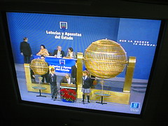
Today closed the Metròpolis Barcelona – El Projecte Comú exhibition on Barcelona’s strategic metropolitan plan featuring 63 projects to extend and develop the city for the horizon 2010. Bruno Giussani has a nice post on it: Walking on Barcelona, and thinking about city design


Relation to my thesis: Location is key when applying for grad school (i.e. Apply to programs in places you would be happy)
Organized by Mobile Monday Barcelona, the Mobile Monday Global Peer Awards 2007 will take place during the upcoming 3GSM World Congress in Barcelona. Around 20 global start-ups, previously selected by Mobile Monday local chapters, will have a brief time slot to perform at centre stage and present their innovation in front of the audience and expert jury. After each performance, the jury will provide valuable feedback about the innovation.
Monday, February 12th 2007, starting at 3PM
Espacio Movistar, Barcelona.
Relation to my thesis: The opportunity to meet some of the world’s best mobile innovations
Presentation of my research on “Uncertainty in Location-Aware Systems” (40MB) at today’s internal mini-workshop.

Relation to my thesis: I am now considering selecting my first sub-question “how certain (cf. taxonomy) do positional and tracking systems have to be in order to be useful and acceptable?” as my main research question. It really fits with my past experiences and with my current interest in the granularity of user experiences in ubicomp (as well as in the accuracy of geotagged images in Flickr).
I blanked on a basic question about the potential applications of my research and started talking about how garbage collectors could profit from it (referring to the Liaison project and my very own thoughts in urban computing) . I am afraid it did not match the audience on that one, but it feels good to get off the beaten tracks (e.g the usual emergency management, fleet and assets tracking) when it comes to location-aware systems.
In the workshop, a talk on the quality of service in networks, made me recall the paper User-perceived Quality of Service in Wireless Data Networks and how I could actually apply the same approach of user-perceived quality in my research.
There is a philosophical level to my research that highlights the mismatches between our needs, expectations and behaviors towards technologies. It relates to Jose Rojas‘ (University of Glasgow) questioning the techno-push in ubicomp and how cultures have a different set of beliefs, goals, aims towards technology.
While trying to shrink my “to-read” list of mails and posts, I stumbled on this freshly kept reference to Kevin Kelly’s, “The Big Here” Challenge. The exercise in watershed awareness (hatched 30 years ago by Peter Warshall) consists in 30 questions to elevate your awareness (and literacy) of the greater place in which you live. The intent of this quiz is to inspire you to answer the questions you can’t initially. You then search the actual answers using the recommendations left by previous quiz takers. Kevin pitches it as follow:
You live in the big here. Wherever you live, your tiny spot is deeply intertwined within a larger place, imbedded fractal-like into a whole system called a watershed, which is itself integrated with other watersheds into a tightly interdependent biome. At the ultimate level, your home is a cell in an organism called a planet. All these levels interconnect. What do you know about the dynamics of this larger system around you? Most of us are ignorant of this matrix. But it is the biggest interactive game there is. Hacking it is both fun and vital.
Questions like “Who uses the paper/plastic you recycle from your neighborhood?”, “Where does the pollution in your air come from?” and “Where does your garbage go?” match my interests in urban awareness revealing the implicit and complex aspects of the city. With a location-based spin, this quiz might become good inspiration for a pervasive game to host (i.e. used as alibi for) my research framework. The “here” would become “wherever”. Both place-based and proximity-based questions could also provide the opportunity to collect data (collaboration to get an answer). For my research interest, I would need to define a couple of elementary actions within locating, searching, navigating, identifying and checking and then design a system with 2-3 different types of location techniques differing in their information quality (e.g. GSM, WiFi, GPS) and timeliness (e.g. automatic vs. manual location disclosure, different types of location update protocols).
Update: Matt Jones got a similar inspiration after reading Kevin Kelly (Here 2.0: Big Here, Little Screen). In a post on Game Cities (Is a great city for playing a game in, the same as a great city for playing in?) he points to a the Barcelona’s Cerda Grid (1859 – 1900) by Ildefonso Cerdà.

In the Economist article on the The phone of the future, Marty Cooper known as the “father of the cellphone” for his work in developing the first mobile phones at Motorola mentions the way mobile phones modified our approach to rendezvousing
But today the idea of “approximeeting”—arranging to meet someone without making firm plans about time or place, and then finalising details via mobile phone while out and about—is commonplace.
Relation to my thesis: Observing the new dynamic of rendezvousing and the balance between flexibility and uncertainty as highlighted in Effect of Location-Awareness on Rendezvous Behavior.
Stefan Steiniger, Moritz Neun and Alistair Edwardes (Department of Geography at the University of Zürich) wrote a lecture notes on the Foundations of Location Based Services. The document aims at identifying the components and participants of LBS applications, describing the interaction of components, and explain what context means, and listing five types of context awareness and list three levels of adaption in LBS applications.
Refering to the work of Tumasch Reichenbacher [1], they categoize the five key mobile actions where geographic information takes a role (locating, searching, navigating, identifying and checking).
Activities during mobility, will often have spatially related actions embedded. These actions result out of user questions or desires. Reichenbacher (2004) identified five elementary mobile actions with respect to user needs on geographic information. The most obvious question is to know where the user himself is with respect to somebody or something else (locating). Users may search for persons, objects or events (searching) and they ask for the way to a location (navigating). Other questions ask for properties of a location (identifying) or they would try to look for events at or nearby a certain location (checking). It should be noted that checking uses not only geo-information but involves also time, since it refers to state of entities or events as well.
1. Reichenbacher, Tumasch (2004): Mobile Cartography – Adaptive Visualisation of Geographic Information on Mobile Devices. Verlag Dr. Hut, München, 2004, ISBN 3-89963-048-3

They also provide a rather complete categorization of LBS applications

Relation to my thesis: I was looking for some time now a categorization of the elementary mobile actions with respect to user needs on geographic information. They mention some user-centered questions I am working on in terms of interactivity and information visualization
User Interface: How can the user or (navigation) system formulate his needs and can make them more concrete after obtaining an overview?
Visualisation: How is the information, returned from LBS, communicated to the user?
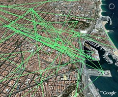
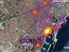
In continuation of my exploration of Flickr geotagged images, I produced the “traces” left in Flickr by tourists and citizens of Barcelona based on around 4000 images taken between october 2006 until now. A trace consists in an ordered set of geotagged images taken by one person in one day. The data and visualizations remain brut, but there might be a potential to define and confirm patterns of how tourists navigate the urban space (e.g. the elephant path along the Rambla, people do not walk to Gaudi’s Sagrada Familia). The maps do not carry the sense of time yet to highlight when and where the traces start and end.
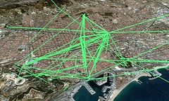
Related to Visualizing the Visitor’s Eye, Mental map of London and Tag Maps: Visualizing the Crowd’s “Mental Map” Using Flickr Geotagged Images
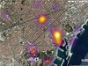
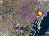
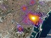
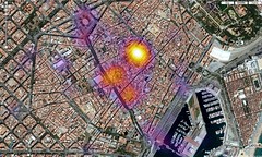
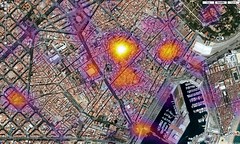
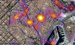
In extension to my previous Heat Map of Barcelona Geotagged Images, I extracted the granularity level used on 4100 geotagged images of Barcelona. Heat maps are on way to find patterns of usage of the granularity feature. I still need to separate manual with automatic geotagging by retrieving the GPS data contained in the EXIF tags.
In a “mining urban activity” perspective I planl to use images timestamps to start to generate the “traces” left by the visitor’s eye.
Levels of granularity used on 4100 images

City view with granularity levels of 8 (region/city level), 9, 10, 11, 12, 13, 14, 15 16 (street level)
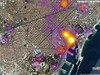

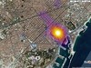
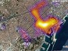
Old city level, with granularities 14, 15 and 16
Quotes in last week’s Mobile Monday Barcelona on Mobile Social Networks.
Alex Kummerman – Clicmobile
Alberto Benbunan Garzón – Moviligo
Felix Petersen – Plazes

Flickr set by Rudy