Posted: October 31st, 2006 | No Comments »
Audio from every talk at last week’s IDEA2006 conference (conference on designing complex information spaces of all kinds) are now available online.
Urban Mapping‘s Ian White gave a talk on the design of data (MP3).

Ian White: The Design of Data (PDF)
In short, Ian talks about mapping complex georeferenced data and how the design of data influences the experiences the users will have. Prior to any product definition he categorizes data in their context of use:
- Mode (driving, public transit, bicyle)
- Environment (urban, rural, indoor)
- Domain opportunity (mixing mode and environmeent, e.g. public transit urban)
- Constraint (tempoal, technical logisical)
From his experience with print (i.e. Panamap) and his “quest to sell polygones” (i.e. a geospatial database of neighborhood boundaries they license) Ian mentioned a couple of issues that are right on the spot with what I do:
‘How Location Aware are You?’

Geo-aware device often offer a “range of uncertainty” and we know that we do not know how certain you are (knowledge typologies). It would be nice if you could make it explicit.
Centroid issue

In practice, a neighbor is defined with average centroid based on population density and then a radial curve is drawn. This barely represents reality in many cases and in the context of use many time useless.
In the field of building application taking advantage of geodata, Ian advises to
- Study the context of use of the users (qualitative data)
- then segment it rigorously
- Design is a process
- iterate!
It is really very similar to my design-science research approach.
Relation to my thesis: I am hardly interested in how the design of data influences the experiences the users will have. I am not sure I will apply methods that can answer that. Context of use is something I plan to categorize as well. The temporal (4th) dimension of data was barely mentioned, while I see it as one of the 3 main source of uncertainty. The problematic of defining neighborhood and how it should match the user’s perception of this space provides me of an example of uncertainty that comes from the processing of the geodata.
Posted: October 31st, 2006 | No Comments »
Parush, A. (2006): Bridge the gap: Toward a common ground: practice and research in HCI, interactions Volume 13, Number 6 (2006), Pages 61-62.
Via Nicolas. This article underlines the gap between research and practice in HCI. Primarily because practitioners express difficulties in benefiting from research. HCI is a discipline concerned on the one hand with practice (design, evaluation, and/or implementation of interactive computing systems), and on the other, with the research into phenomena associated with this practice. The ability to utilize and benefit from any of the research types depends on how a practitioner defines his practical problem as a research question. The author distinguished 4 tiers in HCI research: usability, comparison, guidelines and theory.

These dimensions differs according to the “level of focus” (”range from addressing questions focusing on a specific product, to comparing between products, to searching and examining guidelines for a family of products, through to general questions on behavioral, social, organizational, and other phenomena“) and “extent of generalization”.

The ability to utilize and benefit from any of the research types depends on how a practitioner defines his practical problem as a research question. The abstraction of the question on different levels can lead one to search and find potentially beneficial research that can be applied in the practical arena.
Relation to my thesis: Currently writing my research plan I wonder how may research could have practical benefits. The 4 tiers are a good help to frame my goals and methods. Usability testing (and participatory design) to get information on the usability of my design, comparative information from literature review, guidelines from field studies (are they real behavioral research methods?), and then try to derive theoretical implications (model for a specific phenomenom?). Things are still fuzzy…
Posted: October 29th, 2006 | No Comments »

The WSJ has an article on the new generation of GPS-based personal navigatoin devices or so called “personal companions” or “travel companions. In the hopes of encouraging people to carry them wherever they go, many companies have added instant messaging, photo viewers, travel guides with information like restaurant reviews and MP3 players. Featured GPS/PDA hybrid devices that are meant to be used meant to be used by walkers as well as drivers include the Garmin Nüvi, the HP iPAQ rx5900 and the Mio DigiWalker H610.
Drawbacks of such devices are:
- small screens that can be hard to see
- lack of detailed maps (topographical contour maps)
- service continue to route you on streets as if you were a car
- no update of information (look for an ATM and find out that the system sent the user to an ATM that had be removed)
No mention about the quality and coverage of the positioning technologies and how these devices handle them. The same day, Rich of Mapping Hacks wrote a post on plotting waypoints and track logs showing how spotty GPS coverage was in Amsterdam during his last visit.

But I have become partially disillisioned with how really very bad the coverage really is. I still believe in position, but the GPS is not the ultimate answer.
Relation to my thesis: Personal navigation devices compete with GPS-based cellphones in offering services to pedestrians and car drivers. The shortcomings of positioning technologies are not taken into consideration for the review. Details in the maps and accuracy of the information of the points of interests seem to be the most important.
Posted: October 28th, 2006 | No Comments »
Nicolas pointed to me the now (partially) online PhD dissertation of Jane McGonigal entitled This Might Be a Game: Ubiquitous Play and Performance at the Turn of the 21st Century. In chapter 3 Colonizing Play: Citations Everywhere, or, The Ubicomp Games, she explores the role of experimental game development in producing research insights in ubicomp (in our case mutual location-awareness in physical space, technological boundaries and design strategies to be applied) and persuading that the vision of ubicomp is worth pursuing (we do that by deploying an engaging context). She discusses our work on CatchBob! with her performance studies perspective from which the ubicomp field can learn a lot, as I did while reading that chapter. I am glad she included our paper Getting real with ubiquitous computing: the impact of discrepancies on collaboration as part of the “Are we there yet?” (in the 2003-2005 era) discourse. Converging with my impressions of the last UbiComp conference, it has become clear that this question cannot be answered because the “there” (ubicomp desired state) is very ill defined and fuzzy. From the pervasive games reviews by Jane (expect the later seamful games), I do not think they were setup to stage the imperfection, but that came up as an unexpected research outcome of the first real-world runs of CYSMN and CatchBob!
Even if not specifically mentioned, I think that it is understood that we used our game platform as an alibi for our research. I think that as suggested by Starner (2000) gameplay is perfectly suited to smoothing over the inevitable flaws and incompleteness of early technology deployment. However, it is true that, as underlined by Jane, we completely under-produced play. A trait of academic pervasive games is that neither the player nor the game take center stage, but rather the technological and interface aspects. The experiments stage an artificial (if not fake) world for the user to try out. Ciarletty (2005) describes this as the “fake it” environments and missions of so many ubicomp tests (in our case the influence of the experimental psychology approach that constraints us to defined an artificial task).
The dissertation bibliography is available as well.
Relation to my thesis: Happy that my work is cited outside my strict research community. As I wrote it very early in my PhD adventure (1 month), I do not consider (and was told) that the eMinds paper has of big scientific value, but this proves me that other communities (other research communities, industry, designers, artists) can profit to that type of outcomes. I intend my applied research to stay on this accessible track.
I could find some references I could use such as Albert Schmid (2003 or? 2005) encouraged his HCI audience to continue aggressibely pursuing Weiser’s vision, “confronting real people in real everyay environments” with more and more functional ubicomp prototypes. Schmid argues that “developing complex system isn’t a new problem. However when looking at ubicomp system, understanding the full complexity is often differnt and more difficult than in ares of more bounded scope.
References:
Ciarletta, Laurent. “Emulating the Future With/Of Pervasive Computing Development.” Online Proceedings of the Third International Conference on Pervasive Computing. Munich, Germany: 8-13 May 2005.
Schmidt, Albrecht. “Interacting with the Ubiquitous Computer.” Keynote lecture at the Fifth International Symposium on Human Computer Interaction with Mobile Devices and Services. Udine, Italy: 8-11 September 2003.
Schmidt, Albrecht, Nigel Davies, James Landay, and Soctt Hudson. “Rapid Prototyping for Ubiquitous Computing.” Pervasive Computing. 4:4 October-December 2005. 15-17
Starner, Thad, Bastian Leibe, Brad Singletary, Kent Lyons, Maribeth Gandy, and Jarrell Pair. “Towards Augmented Reality Gaming.” Proceedings of IMAGINA 2000 Conference. Monaco: 31 January-2 February 2000.
Posted: October 27th, 2006 | No Comments »
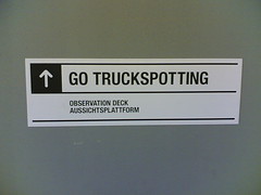
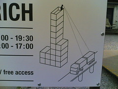
Enjoying the Freitag truckspotting tower.
Posted: October 27th, 2006 | No Comments »
The upcoming Mobile Monday Barcelona event will be on “Proximity Marketing” (19h30, November 6, 2006, Auditorium of the Pompeu Frabra University).

(Image courtesy of FuturLink)
I exptect to hear (and meet)
- Futurlink‘s David Masó on their “Wilco” access points with Bluetooth designed to trigger the interaction with mobile phones users.
- Media Contacts‘ Joan Grau, on the challenges of implementing proximity marketing solutions
- Nike’s Paulino Moraleda on their visions of proximity solutions.
Relation to my thesis: mingling with the industry
Posted: October 26th, 2006 | No Comments »
A IEEE Pervasive special issue on Urban Computing has been initiated by Tim Kindberg (HP Labs Bristol) and will be co-edited by Eric Paulos (Intel Research, Berkeley), Michael Joroff (MIT, School of Architecture and Planning), and Matthew Chalmers (University of Glasgow)
The Call for Papers give the following description:
IEEE Pervasive Computing invites articles about urban computing: the integration of computing, sensing, and actuation technologies into our everyday urban settings and lifestyles. Successful integration requires taking several facets of the urban environment into account at once. Urban settings frame social behaviors; they encompass architectural forms and features that may or may not be harmonious with given technologies; and they are increasingly but variably permeated by wireless networks and fixed and mobile devices. A key challenge is the great diversity and density of people, devices, and built artifacts found in urban places. Urban computing ranges from city-wide transportation-sensing infrastructure, to services embedded in a cafe, to the bluetooth “aura” of an individual’s mobile phone as he or she walks down a street.
Relation to my thesis: Fits to my interests in wireless society, citizen sensors, urban interaction, urban experiences, downtownware, city as a system, design for appropriation, space syntax, and urban real-world deployments. Publication due in June 2007
Posted: October 25th, 2006 | 3 Comments »
Summary of the pointer shared during my last week meeting with Urban Ecology Agency of Barcelona researcher/architect/computer scientist Yuji Yoshimura.
While talking about the dark side of technologies and how to use them he mentioned by the work of french sociologist Paul Virilio around technology and accidents (accident is diagnostic of technology).
On my idea to build an experiment around tourists in Barcelona (investigate their navigation in a unknown urban environment with a preset mental model from tourist guides), he referenced me the work of Antonio? Rubio on defining a mental map Barcelona: Rubio,A.(1995): la imatge mental de l’Eixample de Barcelona. en A.Serratisa y otros, Semiotica de l’Eixample Cerda, Barcelona: Edicions Proa, 33-43. Similarly there was an exposition last year sponsored by Telefonica Foundation on mobility called “Mira cómo se mueven. Cuatro ideas sobre movilidad“.
Yuji is working on the modeling and simulation of pedestrian navigation in urban spaces. A very immature field, because it still extremly hard to collect real data and evaluate the models. A few goups work on that subject, the main one being Space Syntax. It is the laboratory at the Bartlett school at University College London. They built a simulation that predicts the relationships between urban morphology and the number of pedestrians. Carlos Rotti question their approach in: Ratti, C. (2004). Space syntax: some inconsistencies. Environment and Planning B – Planning and Design 31(4), 501–511.
Another institution working on that domain is CASA. I was aware of Intelligent Space Partnership.
We talked about spatial annotation and the WikiMap project by the Medialab Madrid. Similarly, there was a project ran a few weeks ago on the “Inaccessible Barcelona” in which 40 people with disabilities used mobile phones to photograph every obstacle they come across on the city’s streets. By means of multimedia messages they create a web map of inaccessible Barcelona. This project is part of a larger initiative called Zexe that allow people with disabilities, prostitutes, gypsies and taxi drivers broadcast from mobile phones. We talked about the incentives of spatial annotations and why it sometimes (often) fails.


Spatial annotation (pictures + comments) done by disabled people with mobile phones on the inaccessible spaces in Barcelona.
That lead use into talking about the difficulties of urban data collection and projects such as traffic noise mapping.
Relation to my thesis: First lunch already lead to common project ideas. I also plan on Yuji’s support to help me contextulize my experiments in a real-world urban environments. He has a lot of experience in that domain.
Posted: October 24th, 2006 | No Comments »
Pals Nicolas Nova and Laurent Haug announced the lineup for the upcoming LIFT07, A conference about the challenges and opportunities of technology in our society. 7-8-9 February 2007 Geneva, Switzerland
Join us next February to hear talks about the Web (Stephanie Hannon of Google, Pierre Chappaz, Sampo Karjalainen of Habbo Hotel, Lee Bryant, Colin Henderson or Daniel Kaplan), ubiquitous computing and the Internet of Things (Adam Greenfield, Anne Galloway, Daniela Cerqui, Julian Bleecker, Frédéric Kaplan), mobile technologies (Nathan Eagle, Jan Chipchase), interactive arts and design (Jan-Christoph Zoels, Régine Débatty, Christophe Guignard), entrepreneurship (Bernino Lind), Fair Economy (Paola Ghillani), Ethics (Beth Krasna), and many more topics like education, religion, the digital divide or technological overload.
More than hearing great speakers, I look forward to the special event that will be a bridge between creativity and pragmatism, gathering individuals of various backgrounds to work freely on “Digital fragility“.
Relation to my thesis: LIFT is one of the year’s best opportunity to meet the usual and unusual suspects in the domain of ubiquitous/mobile computing, Internet of Things and interactive design.
Posted: October 24th, 2006 | No Comments »
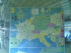
Map of Europe for the Spanish Railway (RENFE) network connections as seen in Barcelona. I had never seen Switzerland shaped like this.
Relation to my thesis: the need of precision to deliver spatial information. In that case, a distorted country borders does not seem to really influence the reading of the map and the user cognitive map is not challenged.


