Posted: January 31st, 2008 | No Comments »
Stumbled across an essay of Bruno Latour entitled “Beware your imagination leaves digital traces” published in Times Higher Literary Supplement, 6th April 2007 in which he describes the massive consequences for social sciences to get access to digital traces:
The situation is entirely different with the digitalisation of the entertainment industry: characters leave behind a range of data. In other words, the scale to draw is not one going from the virtual to the real, but a scale of increasing traceability. The stunning innovation is that every click of every move of every avatar in every game may be gathered in a data bank and submitted to a second-degree data-mining operation.
I am sure that this accumulation of traces has enormous effects for the entertainment industry, for specialists in marketing, advertising, intelligence, police and so on, but another consequence is worth pointing out. The precise forces that mould our subjectivities and the precise characters that furnish our imaginations are all open to inquiries by the social sciences. It is as if the inner workings of private worlds have been pried open because their inputs and outputs have become thoroughly traceable.
[...]
The ancient divide between the social on the one hand and the psychological on the other was largely an artefact of an asymmetry between the traceability of various types of carriers: what Proust’s narrator was doing with his heroes, no one could say, thus it was said to be private and left to psychology; what Proust earned from his book was calculable, and thus was made part of the social or the economic sphere. But today the data bank of Amazon.com has simultaneous access to my most subtle preferences as well as to my Visa card. As soon as I purchase on the web, I erase the difference between the social, the economic and the psychological, just because of the range of traces I leave behind.
[...]
Dozens of tools and crawlers can now absorb this vast amount of data and represent it again through maps of various shapes and colours so that a “rumour” or a “fad” becomes almost as precisely described as a “piece of news”, “information”, or even a “scientific fact”.
[...]
The consequences for the social sciences will be enormous: they can finally have access to masses of data that are of the same order of magnitude as that of their older sisters, the natural sciences. But my view is that “social” has probably become as obsolete as “natural”: what is common to both is a sort of new epidemiology that was anticipated, a century ago, by the sociologist Gabriel Tarde and that has now, at last, the empirical means of its scientific ambition.
Relation to my thesis: Bruno Latour mentions the emergence of digital traces coming from the “virtual world” (sticking with the descriptions of second world and amazon’s social navigation). I would add that some of these traces are intrinsically important because they are general through the interaction with digital means within a physical context.
Posted: January 27th, 2008 | No Comments »
Last Wednesday, I gave a 20min brownbag talk at the giCentre at the City University in London. The presentation was divided in several parts. First, I define the shortcomings in location-aware computing and their consequences that generate a socio-technical gap. I continued by highlighted that the problems do not necessarily lay in the immaturity of technologies, but also in the failure to match people’s own perception of space (granularity, multiple-spaces). Then I detailed the evidences of this gap from my studies and observations of the appropriation of location-aware applications (CatchBob! and Satnav in Taxi). That lead me to describe an approach that leverages digital traces to tailor location information and define user’s the area of attention and their perception of area of influence of points of interest. In that context, I described the Tracing the visitor’s eye project and briefly introduced the context of future experiments (WikiCity and the Wireless City). The slides are online (5.5MB).

The presentation generated lively exchanges with Jonathan Raper, Jason Dykes, Aidan Slingsby, David Mountain, Jo Wood that benefited me to frame of my thesis. Besides arguing on the potential of volunteer generated information (VGI), the discussion centered on the influence of the presentation of location information on the behavior of people (the difference in the communication in CatchBob! (passivity), multiplicity of the sources of information and location-information trunking for taxi drivers) and these behaviors influence the data (feedback loop in WikiCity, geotagging in Flickr). I was in fact advised to focus on how the co-evoluation between location-aware systems and their user’s practices/behaviors (data influencing the behaviors influencing the data).
Relation to my thesis: This week’s trip in the UK is about testing my ideas and approaches with a verity of experts from different fields (I got the pleasure to meet UCL’s Jon Reades to discuss urban planning and urban computing). I must admit that it is a truly rewarding experience to pick the brains of geographers, geovisualization experts and social scientists and have them criticize my work. Presenting and arguing on the current state of my research work should help me create a “meme” and that everybody starts to believe my “story”. Many people have now advised me to get back to my different experiments and (re)define what there is to study for each of them. Categories or research thems and specific question should help me focus on 1 specific aspect and help me find the gaps in “my story” (e.g. thesis).
Posted: January 22nd, 2008 | No Comments »
A couple of paper that discuss the emergence of the large data generated by sensor now sharing our lives:
First, Data management in the worldwide sensor web draws the big picture in mentioning that now too much attention has been placed on the networking issues of distributed sensing and too little on tools to manage, analyze and understand the data. The authors ask the question weather we can design sensor networks with data quality in mind? They ask a very crucial question, but as often in location-aware computing, it is very unclear on who can claim what quality in location information is or in other words who can answer “how good is good enough?”. Of course it is important to manage temporal and spatial data and handle their inherent uncertainty (e.g. via probabilistic theory) or mask it (e.g. via interpolation) or play with it (seamful design). It seems clear now that my thesis is about acknowledging that situation (uncertainty in the location information, fluctuant quality in the data), but instead of aiming to produce “perfect data”, I plan to provide an understanding and solutions from a human and urban perspective. It comes, at the first place, with the observation of people experiencing location-aware systems in CatchBob!, and making use of location information, in my taxi driver (co-evolution, context and granularity). This observations help me accumulating evidences on the contextual factors influencing the granularity (≈human expectation of quality) of the location information used.
Balazinska, M., Deshpande, A., Franklin, M. J., Gibbons, P. B., Gray, J., Hansen, M., Liebhold, M., Nath, S., Szalay, A., and Tao, V. (2007). Data management in the worldwide sensor web. IEEE Pervasive Computing, 6(2):30–40.
Second, Citizens as Voluntary Sensors: Spatial Data Infrastructure in the World of Web 2.0 discusses that the most powerful sensor web is made of the 6 billion humans occupying Earth’s surface. This large collection of mobile and intelligent sensors will affect the processes by which geographic information acquisition and compilation (VGI: volunteered geographic information). The data generated suffer similar issues as a top down (authoritarian, centrist paradigm) when it comes to the fluctuating quality in the data and trust. However, the notion that citizens with means of taking measurements is at the source of the solution to the problems mentioned above. The analysis of how these “citizens” handle and annotate their measurements and observations allow to further understand the influencing factors in the use of location granularity. This is why I study Flickr users in their spatial annotation practice and in their use of geographic semantics.
Goodchild, M. F. (2007). Citizens as voluntary sensors: Spatial data infrastructure in the world of web 2.0. International Journal of Spatial Data Infrastructures Research, 2:24–32.
Third, the digital traces (shared measurements/observations) left by people in space allow to define a human description of space (e.g. citizen definition of a neighborhood). This type of sensor web data can only make sense with geovisualization, as the ones presented in Interactive Visual Exploration of a Large Spatio-temporal Dataset: Reflections on a Geovisualization Mashup. The authors explore the new opportunities for visualizing sensor web data to explain user behaviors. Tools such as Google Earth provide a quick support for visual synthesis and preliminary investigation of digital traces.
Wood, J., Dykes, J., Slingsby, A., and Clarke, K. (2007). Interactive visual exploration of a large spatio-temporal dataset: Reflections on a geovisualization mashup. IEEE Transactions on Visualization and Computer Graphics, 13(6):1176–1183.
Relation to my thesis: Each of these three paper give an overview of the main themes of my thesis that aims to take a human and urban perspective to define the quality of location information:
1. Issues in the quality in the location data (uncertainty).
2. New data to observe people handle/experience location granularity in order to collecting evidences.
3. New visualization to reveal how people perceive and describe the urban space
Posted: January 21st, 2008 | No Comments »
I am off to the UK to visit Jonathan Raper‘s giCentre and Steve Benford‘s Mixed Reality Lab.
Posted: January 19th, 2008 | No Comments »
In the follow-up of the Cyclist Dynamics in Barcelona hack, I met a couple of people related to the deployment of Bicing (community bicycle program in Barcelona). I mention deployment and not maintenance or enhancement because, to my surprise, very little (euphemism) is done to understand how the system is actually used and how its users appropriate it. I am wondering if this come from the background of many urban planners who are in fact architects. It seems that in this domain, there is no strong practice in evaluating what has been done. This shortcoming is obvious when observing the success and failures of Bicing. I apprehend of an urban future enhanced by technologies in the sole hands of architects.
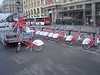
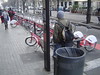
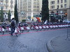
Observing the daily functioning of Bicing, with its “artificial” balance of bike from one station to another, fixing station, users waiting in front of a full station, and a station temporarily out of order.
The spatio-temporal visualization of the system status [video]
Relation to my thesis: thinking on the design for appropriation of technologies and how we can take advantage of the digital traces left by people interacting with technologies to reveal and act upon the imperfections of the systems.
Posted: January 19th, 2008 | No Comments »
In Denis Wood’s Cartography is Dead (Thank God!)
I have no interest in belittling the positive contributions made by the generations of academic cartographers – but there’s a lot that was dead wood to begin with, and is so rotten today it’s threatening the rest of it. All the prescriptive bullshit, every map must have a legend and a scale – all that – ignored in fact on a gazillion effective, useful maps, all that has to stop. And design! Academic cartographers have never understood a thing – not a thing -about design. God knows that, as a group, the least interesting, least attractive, least significant maps have been made by university cartographers: all that design talk, from design illiterates, that’s got to stop.
Relation to my thesis: A new type of science of mapmaking (or communication through maps) will need to take into account geo-communication mechanisms (as suggested by Lars Brodersen) and an understanding of the user and its context to inform the design. It will also need to inspire and communicate with the artists, engineers, designers, urban planners, … sociologists, ethnographers, psychologists, visionary, … astronomers, “canal diggers” who inspire compelling and significant work such as Kevin Lynch’s “mental maps” of Boston or Joseph Minard’s Napolean March.
Posted: January 19th, 2008 | No Comments »
In Augmenting amusement rides with telemetry, the authors present a system that uses wireless telemetry to enhance the experience of fairground and theme park amusement rides. The appealing aspect of this work consists in capturing data of people experience and subsequently visualizing it back to the audience and experts in medical monitoring, psychology and ride design. The analysis and visualization of these records provide five main possibilities to enhance the user experience:
- enabling designers to understand at precisely which moments riders feel the most thrill and also how different people react to different rides, supporting the more systematic design of more thrilling rides.
- design future rides that directly adapt to individual riders’ preferences or past history, for example tuning their movements in response to telemetry data, providing a more personalized riding experience than is currently possible.
- enabling amusement rides to be reliably rated for the experience they deliver.
- extending the spectator experience to include ‘tele-riding’ through a more immersive presentation of the telemetry data.
- producing richer souvenirs
Walker, B., Schnädelbach, H., Egglestone, S. R., Clark, A., Orbach, T., Wright, M., Ng, K. H., French, A., Rodden, T., and Benford, S. (2007). Augmenting amusement rides with telemetry. In ACE ’07: Proceedings of the international conference on Advances in computer entertainment technology, pages 115–122, New York, NY, USA. ACM.
Via Nicolas’ From telemetry in trace park to the usage of urban (digital) traces.
Relation to my thesis: This is a very nice example of leveraging digital footprints (e.g. telemetric data) to enhance the user experience. The possibilities reflect well some of the thoughts on “feedback loop” or “control loop” discussed previously and on social navigation suggested in Leveraging Urban Digital Footprints with Social Navigation and Seamful Design. How can this successful approach be transplanted from a theme park into the city to enhance the residant/tourist experience?
Posted: January 19th, 2008 | No Comments »
As part of the Workshop on Volunteered Geographic Information late last year, John Krumm presented a position paper on Exploiting Users’ Map Annotations. In the project, he exploits Live Search Maps’ “Collections” to assess the prominence of existing landmarks and to find new landmarks that should be added to the map. More interestingly, he first mentions the use of this type of data to “determine which landmarks to show at different zoom levels, as a way to describe more obscure locations in terms of prominent ones (e.g. 0.5 kilometers east of Pike Place), and as a way to pick landmarks to give driving directions“. This very similar to part of my work on Tracing the Visitor’s Eye that I presented last year at Ubicomp. Second he talk about an “algorithm for finding new landmarks from collections. In brief, this proceeds by first making geographic clusters of pushpins, extracting all possible one-, two-, and three-word phrases from the associated text, and processing these phrases to find which ones are mentioned frequently in the cluster (e.g. “Space Needle”), but not very often outside the cluster.” I have been developing a similar approach for my project on Florence to reveal the major POI of the city and define their “area of attraction”.
John Krumm is the guest editor of an upcoming special issue of the IEEE Pervasive Computing Magazine on Pervasive User-Generated Content. The CFP introduces the theme as follow:
Pervasively situated people and things can generate content otherwise unobtainable. Small contributions aggregated from a large number of individuals add up to richly minable supply of information and also make the data more credible and reliable. Sometimes the data is generated explicitly, like event reviews, store ratings, and incident reports. Other times, the data comes from analysis of normal behavior, like aggregating traffic speeds from regular drivers. Often people provide the data, like networked games designed to extract everyday knowledge. In other instances, objects like paper currency or ocean-borne, spilled toys are tracked as they move around naturally. The resulting content sometimes comes from sophisticated processing, like inferring driving preferences from observed trips. In other instances, processing is minimal, like text messages displayed publicly in Times Square. In all cases, a critical link is a network that connects the pervasively distributed data sources to a central repository.
Posted: January 18th, 2008 | 2 Comments »
In the context of my BCN taxi driver study, I have been reading some of the word done by Silvia Elaluf-Calderwood on the organizational ability of London Black Cabs with mobile and wireless technologies. The study was conducted as part of the research network for Mobile Interaction & Pervasive Social Devices that support research on socially situated technologies, the socio-technical aspects of mobile working and on the mutual adaptation of work practices and mobile and wireless technologies.
Silvia performed a longitudinal ethnographic study with empirical data provided by qualitative interviews with 35 Black Cab drivers and 14 hours of videotaped observation of driver behavior to highlight some issues of the relationships between the drivers practices and the supporting mobile technology. She focused on the observations of the different socio-technical arrangements the taxi drivers work with:
- Traditional: The Knowledge + mobile phone to keep in touch with family and friends
- Dispatched Radio Taxi: radio call system + electronic booking system + mobile phone
- Automatic Customer-Driver Connection: Real-time GPS location system + satnav + mobile phone

From the interviews she was able to define the main factors that influence to encounter work: physical location, awareness, time, strategic planning, situational acts, planned acts, human factors, role of the technology, emerging practices and chance to succeed. Then she compared each arrangement in the light of these factors. In concordance with my study, she points out that the most interesting technological opportunities may be thwarted by practical barriers such as problems with support of individual taxi work (not coordination) through GPS systems when these assume the driver relinquish control entirely and simply follow directions when these are far from perfect or:
With Arrangement C, in which the driver relies on his mobile phone to obtain work – besides street hails – the ubiquity is wider. Drivers get accustomed to longer runs on specific routes to maximize the number of passengers transported. However passengers sometimes take the first cab that is closer to them and the driver loses his ride. During the interviews drivers in Arrangement B were reported to say that this uncertainty is the main reason they felt discouraged from trying Arrangement C.
Related to my analysis, she also mentions the feeling of relaxation that the technology brings (when the destination is known and pressure of constatly searching for new passengers is reduced by greater trust place in the computer system) but also the distraction it brings to their driving (multiple-tasking, they liked the fact that the system turns off to black screen after two minutes idle) and the accuracy of the GPS system used (billing and payment, outages, when it needs repair it means unplanned time of the road).
In my study, I first analyze under socio-technical lenses how everyday cab driver adapt their working practices depending upon the integration of location-aware technology (co-evolution). However unlike Silivia’s work that focuses on the organization to capture customers, I reveal the implication of acquiring at satnav system on the wayfinding strategies and knowledge acquisition. At a second step, I study the role of context in influence the access of location information (granularity). In that part of the work, I can inspire form Silvia’s list of factors that influence the cab drivers work. Moreover, I should explore the impact of the relation with Suchman’s situated action theory (locations and opportunity determine the action): “Idiosyncrasy, improvisation and knowledge are all useful tools when choices between planned and situation acts are complex” (Suchman, 1987)” and maybe establish a link with the accuracy/uncertainty/granularity of the location information.
Finally, Silvia makes reference to the conflict between using location-aware technology and gaining skills and knowledge of the environment:
Drivers express the introduction of GPS systems as a way of making their “skilled” job an unskilled one; anyone with a GPS could do their job
[...]
The more the driver relies on the system to locate jobs, the less he or she relies on their in-depth knowledge of where they need to position themselves to maximise income.
In fact, my contextual inquiries somehow revealed quite the opposite. First, a navigation system was a mean to gain knowledge on the city (novice drivers have the tendency to leave it on passive mode to learn the street names). As a proof, after installation, the system tends to be used less and less by cab drivers. Second, the few mistakes a satnav system can make challenges the trust novice cab drivers put in the location technology. In fact, they have a tendency to use the street directory and paper maps for the dense urban area (or areas where they have points of reference). Experience drivers mention their feelings that now even freshly arrived cheap labor could do their job (as mentioned by Silvia). The reality proved to be more complicated than that. A satnav system does only do a part of the taxi driver’s job.
Sources:
Elaluf-Calderwoodand, S. and Sørensen, C. (2006). Organizational Agility with Mobile ICT? The Case of London Black Cab Work. Butterworth-Heinemann.
Elaluf-Calderwood, S. and Sørensen, C. (2008). 420 Years of Mobility: ICT Enabled Mobile Interdependencies in London Hackney Cab Work, Mobile Work/Technology.
Posted: January 17th, 2008 | 1 Comment »
LIFT season is almost here with its flourishing workshop proposals. With Near Future Laboratory compadres Nicolas Nova and Julian Bleecker, we organize a session on ubiquitous computing and its discontent. The teaser goes as follow:
The integration of information processing into everyday objects and our environments, often referred to as “Ubiquitous Computing” has been fueled by strong visions such as Weiser’s ‘Calm Computing’ paradigm or Philips’ ‘Ambient Intelligence’. Nevertheless, the ever-increasing number of smart houses, intelligent assistants or mobile location-based applications find niches but has not yet lead to their adoptions by quotidian users. As stated by researchers such as Bell and Dourish, these visions might mislead us into an infinitely postponed proximate future that eventually distracts our attention to what is currently being used and its effects.
[...]
The purpose is to generate debate about the design and integration of ubiquitous systems based on case studies proposed from workshop participants. Moreover, we want to open up a debate around the future of those systems as well as the adoption by a large user base.
[Full text]
Relation to my thesis: a collaborative follow-up from last year’s monologue at LIFT.
