Posted: March 9th, 2009 | No Comments »
In his intervention at Lift09, Dan Hill inspired from Arup’s Total Design to introduce the kind of skillset that would make a team of soft infrastructure architects (software engineers, interaction designers, sociologist, ethnographers, economist, lawyers) to properly bend the physical city. The main challenge to incorporate design informatic systems to greatest advantage without undermining the wonderful things about cities, certainly lies into finding ways to involved disciplinary communities that barely speak the same language and practice with different (contradicting?) objectives. This is certainly the kind of cross-disciplinary pollination Adam Greenfield aims at creating with his upcoming book. In a recent interview Towards a Newer Urbanism: Talking Cities, Networks, and Publics, he digged out a quote I have been looking for a long time from (courtesy of the great Brian Boyer):
“If you want to start talking about some serious cross-disciplinary pollination then you better take both sides of that disciplinary divide seriously. When your ubi- runs into my building with its boring HVAC, mundane load paths, typical finished floors, plain old foundations, etc., the transformative powers of comp are bracketed pretty seriously by the realities of the physical world.”
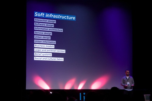
Dan Hill on the skill sets to develop and maintain soft infrastructures. All waiting for some serious cross-disciplinary pollination. Photo courtesy of Vlad Trifa
Posted: March 9th, 2009 | No Comments »
Most research focuses on the technological possibilities and problems of using tracking devices. Little attention is paid to the questions to what extend and in which manner knowledge developed through the use of new tracking technologies might influence spatial design and planning decisions. Therefore, there is a need to go beyond the collection of positioning data sets to the delivery of information and knowledge derived from these data. The Urbanism on Track expert meeting and book take that challenge with its chances, directions and limitations to explore how urban design and planning can embrace tracking technologies, particularly considering that recent studies on public space show urban designers ill capable of estimating the use of space (e.g. Golicnik 2005). So the opportunities to develop a learning loop with indicators and diagnostic tools in urban design and planning that can deal with contemporary urban complexity are present. Of course, spatial planning studies looking for such indicators is nothing new, but tracking technologies could complement these low-tech studies or replace traditional data collection methods such as travel diaries in time-use (my paper in submission “Detecting air travel to survey passengers on a worldwide scale” is an evidence of that).
The content and references of the 7position papers of the expert meeting provide a first glimpse in the ways to develop knowledge through the use of new tracking technologies (see particularly Klaasen, I.T. (2004) Knowledge-based Design: Developing Urban & Regional Design into a Science, Delft University Press, Delft – joining my observations on the urban microscopes and telescopes and the lack of science of what we see). I particularly found intriguing Monica Wachowicz‘ framework to representing different nature and sources of knowledge about people in motion. For instance she categorized movement metaphors of a spatial planning process in: the movement-as-trajectories, movement-as-journey, movement-as-activity, movement-as-urban forms (i.e. considering the constraint by urban forms – something that could be explored in New York)

Courtesy of Monica Wachowicz. Figure 1 illustrates the proposed multi-tier ontological framework, in which a successive set of tiers refine the steps of GKDD process, which are named as sampling, relating to a geographic context, discovering patterns, generating new insights, and confronting them with previous background knowledge. Therefore, five Tiers have been defined as Reality Space; Positioning Space; Geographic Space; Social Space; Cognitive Space.
References:
Golicnik, B (2005) Urban landscape between design practice, usage and reseach. Conference Life in the Urban Landscape. International Conference for Integrating Urban Knowledge & Practice Gothenburg, Sweden. May 29 – June 3, 2005
Relation to my thesis: a good set of references to bring more my paper on urban attractiveness, if it ever gets rejected. Also very useful for the “future work” section of my dissertation.
Posted: March 7th, 2009 | 1 Comment »
At last week’s Lift workshop on the The Design of the Hybrid City of the Near Future (more on that later…), I was surprised how much many participants really wanted to depict the visions of future cities (already studied 2 years ago) and then acted less engaged in dissecting the implications (e.g. the winners and losers, what if it goes wrong, what do we need to go right). There is a real fascination for these visions and I acknowledge that they are useful to maintain consistent progress towards betterment, but if we do not make an extra effort to consider their meanings, we are stuck in a) reflecting on our own visions of the future of the city b) fail to acknowledge the implications behind the improvements and their complexity. Without this exercise it seems that we keep on carrying the visions of the efficiently-built fabric, such as New Songdo or the Venus Project (video), where the city is built from scratch, optimized for non-human variables such as transportation efficiency and separated land use (e.g. EPCOT – video), away from distracting and messy people, very much in the 50s and 60s urban renewal fashion. We know how that turned out great! I am still wondering, how much has been learned from Jane Jacobs since then?

The designing the future video, a contemporary vision of an urban future free from distracting and messy people, by Jacque Fresco
Posted: March 5th, 2009 | No Comments »
On Tuesday, my work was presented in two different venue, in Hamburg at the GeoViz workshop on the Contribution of Geovisualization to the concept of the Digital City (thanks to Ayman Moghnieh for replacing me at the last minute!) and in Barcelona at Globalgeo in a forum on geoinformation and participation for sustainability (slides of the presentation). I stayed in Barcelona to meet some of the founders of the Vespucci Initiative and understand how my work integrates into the current trends and challenges in of geographic information science. Besides the acknowledgment of volunteer-generated information, it is still a very techno-driven field, that starts with technological capabilities of to collect, process and visualize data and after a few years having conference session with the title “So what?”. No doubt that this is one what that innovation happens, but I am always fascinated by the GIS community quest of the details (e.g. the perfect 3d models of a city) without much human perspective on “how good is good enough” and “for whom and what for”. Current concerns are rather on better organize the existing geospatial data (following the EU Inspire Directive), migrate them to Internet-based environments, make them ready for spatial analysis and visualization. In relation to that, spatial data should be considered as a medium, not a message. So far the community has overlooked the maintenance of the medium, for instance in failing in archiving data (e.g. we lack of the digital data from 10 years while we still still have analog data). In addition, there is paradigm shift that drives spatial analysis to show what is happening, not what it is, implying the development of 4d spatial analysis and visualizations systems.
The move into this Next Generation Digital Earth goes through the embracement of bottom-up spatial data infrastructures. Michael Goodchild made an effort in comparing the differences in quality, trust, timeliness and risks of volunteer generated information vs. authoritative information. He particularly talked about the contrast in the quality of the top-down (authority) data where inaccuracies are guaranteed and the bottom-up (assertion) data that tend to be more accurate in popular places (e.g. similar to Wikipedia). Therefore, authorities information must be verified through a process that can be slow. On the other hand, asserted information are generated in timely manner and people are willing to accept the false positive they generate (an angle that I could have explored in CatchBob). Through several examples (e.g. fire management in Santa Barbara), Goodchild showed the necessity to consider both accurate top-down information mixed with timely volunteer generation information (e.g. such as in Zagat). My work in New York certainly goes into that direction.
Posted: March 2nd, 2009 | No Comments »
Back from Lift09 with my traditional doggie bag (see Lift06, Lift07, Lift08) filled with food for thoughts and unlikely take-aways (all the videos are online).
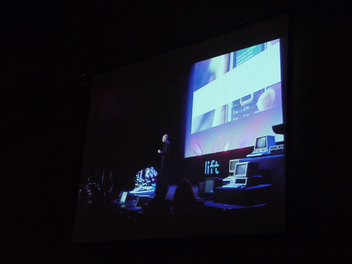
This year, I got the pleasure to moderate the “Towards a long here” session, a title inspired by Adam Greenfield’s concept of Long Here and Big Now. Carlo Ratti, Dan Hill and Anne Galloway shared their take on the challenges, problems and opportunities of the recombination of urban environments through technological advancements. First, Carlo Ratti gave a punchy rundown (fing’s notes) of the MIT SENSEable City Lab’s projects, with a nice homage to my tracing the visitor’s eyes. Each project provides an evidence that bits and atoms are coming together to reveal invisible urban dynamics (Real-time Rome, NYTE, World’s Eyes, Track Trash) and provide new types of experiences in urban space (WikiCity, Digital Water Pavilion). Without devaluating the importance of engaging visualizations of urban dynamics, Dan Hill (fing’s notes, Dan’s notes) showed evidences of the less happy marriage of soft and hard infrastructures from his frustrating 4-days journey to reach the northern hemisphere. It is when soft infrastructures “attack” (exception handling when rerouting passengers of a malfunctioning 747, lack of information system, smart card at the hotel not working) that we get the feeling of their importance (making me think to the Code/Space concepts). Bottom line: “it may not matter how good the hard infrastructure is, it is the soft infrastructure that affects how you feel“. Therefore, software infrastructures are not only about technology, it is also about software design, service design, interaction design, looking at the wider context of the organization, systems and people, urban design, urban informatics and even business models, the legal and political context, the belief systems and the social and cultural fabric. If we do not understand these aspects, we will make the same mistakes as past visions that relied on the fascination around the hard infrastructures and reducing cities to systems. When stepping back and considering the future with and understanding of why past vision never happened, it becomes clear that people (social, cultural, political such as privatization of properties) drive the evolution of cities, not technology (here I like to talk about co-evolution). Taking that into account, the exploitation of these soft infrastructure might lead to promising “super-powers” (here Matt Jones’ latest talk “The Demon-Haunted World” with the quote “the car changed the development of the city irreversibly in the 20th century. I’d claim that mobiles will do the same in the 21st” comes to mind): a) control of the transit network, not the other way around (e.g. visualization of Velib nodes revealing new movements in cities), b) ability to see the invisible activity, c) post-occupancy evaluation and feedback loops.

Dan Hill and the animated Velib nodes trick…
However the development of these “super-powers” and the improvement of the relationships between hard and soft might not come without a engaging the actors (I see using visualization as one way to stretch the imagination and engage into the action), b) user-centered design (the web industry could teach the architecture world, like the learned from product design and industrial design!), and c) Ove Arup’s “Total design” with an architecture team made of new disciplines such software engineers, interaction designers, sociologist, ethnographers, economists. Anne Galloway (fing’s notes), stepped away from a utilitarian discoursed and perfectly built on Carlo Ratti and Dan Hill’s suggestions, and the expressions of expectations, promises and hopes around these future cities and their informational membrane. If we consider the design of these cities and their positive aims as a gift (gift taken within its complex interaction): it might imply a gift back (uneven expectations), it might not be well interpreted (like any awkward gifts). So if we offer citizen better awareness of the city dynamics and power to influence the city evolution, does not mean they will accept the gift. Indeed, taking the example of citizen-science and people-centric sensing, citizen might just not be interested in the collect of the data, it might increase the divide between the people who are able to participate and the ones who don’t (as discussed in The rise of the sensor citizen).
Some speakers discussed the study of failures (Nicolas Nova) and the acknowledgment of chaos (Fabio Sergio discussed that hope and dreams carried in design only show a perfect world, a world that does not exist, and then had the necessary slide on the Napoli garbare issue) as part of the design process. It was music to my hears after talking about seamful design and mesiness at lift07.
A workshop on the design of hybrid cities of the near future also took place. More on that later…
Once again, the Lift Conference outdid itself, a conference that has the self-confidence to take chances in inviting unlikely but refreshing speakers (Baba Wamé, Frank Beau) mixed with safe bets that always deliver beyond expectation (Matt Webb, Fabio Sergio, Dan Hill, Anne Galloway…) and open stages with a smart sense of provocation like Bill Thompson’s the death of privacy or inspiration with Felix Koch and Fabian Keller on the literacy of cutting. Lift is THE conference of the World-Wide Lab, the best hybrid forum out there. There is still a need to work on the workshops formats to get back to lifto6′s level.
Once again, my hat is off to the organizers!
Fabio Sergio at Lift Conference 2009
Posted: February 20th, 2009 | No Comments »
Shoval, N. (2007). Sensing human society. Environment and Planning B: Planning and Design, 34:191–195.
In this paper Noam Shoval proposes referring to the possibility of the aggregative use of cell phone spatial data as human sensing. He makes the distinction with remote sensing that applies more to the domain of physical geography arguing that human sensing enables us to sense people directly, in contrast to remote sensing, where the information obtained regarding human activity is indirect. Even if new sources of physical geographic data is related to aspects of human spatial activity, none of them can be thought of as materially augmenting more traditional social scientific data that describe the social characteristics of individuals and groups. Now the emergence of human sensing coupled with the considerable progress in the field of GIS, currently places us on the verge of a veritable revolution in human time-space activity research.
The author introduces the two methods of analysis of location data of cell phone that I have explored in the course of my thesis. First from the activity of devices that are associated with each antenna of the network during a certain period of time. Second, the detection of the location and migration of devices over a given period of time on the different antennas of the networks. Both approaches raise privacy issues, even though Noam mentions that “the data derive from statistics regarding activity in antennas and not regarding the locations of the phones themselvesötherefore there should not be any privacy considerations in this case”, comparing the approach to study census data for which “detailed census records at the individual household level are not usually available to researchers. Data are available only in aggregated forms at a level of detail intended to prevent the ready association of demographic information with individual households.”
Other challenges confirms the limitations that have emerged from my thesis works: a) aggregated cellphone data are particularly difficult to deal with high-resolution
interurban analysis; being more appropriate for studies of relatively low geo-graphical resolution, such as at the metropolitan level b) the representativeness of the cellphone data than necessitate calibration methods (although such issues must be addressed in any other research method as well)
Interestingly, Noam suggests the observation cellular network infrastructure already reveals general idea about the main nodes of activity in cities, such as concentrations of business activities, shopping, and leisure, such as here for Manhattan:

Image courtesy of Noam Shoval (original), created by Adi Ben-Nun from the Hebrew University GIS Centre, of a density map of around 1300 cellular antennas in Manhattan.
Relation to my thesis: “Time will tell whether the contribution made to human geography and the social sciences with this methodology will be on a par with the revolution generated by remote sensing in the field of physical geography and related geosciences.“
Posted: February 19th, 2009 | No Comments »
The 6th edition of the Digital Cities workshop series, organized by Marcus Foth will discuss urban informatics systems that provide real-time tools for examining the real-time city, to picture the invisible and to zoom into a fine-grained resolution of urban environments that reveal the depth and contextual nuances of urban metabolism processes at work. Particularly, participants will engage in discussing the research approaches that can differentiate (and break apart) a universally applicable model of ‘The City’ by being sensitive to individual circumstances, local characteristics and socio-cultural contexts, leading to the development of a toolbox of what could be termed anthropological urban anatomy. This toolbox would aim at better understanding the ‘city’ as an organism needs to help understand “how do the cells of the city cluster to form tissue and organs, and how do various systems communicate and interact with each other? And, recognising that we ourselves are cells living in cities as active agents, how do we evaluate the effectiveness and efficiency of the processes we observe in order to plan, design and develop more livable cities?“
Posted: February 19th, 2009 | No Comments »
The Digital Cities: London´s Future exhibition and series of events (Digital Tools for Urban Design and Virtual Tools for Creating our Built Environment) are coming to and end leaving an online catalogue behind them. The tools and techniques for planning, organisation and governance of showcased in London’s Future reveals a fascination for the digital geographical data and 3D models that seems to completely overshadow the human and social layers of the digital cities. For instance, the catalogue on Digital Cities: data and democracy contains only a couple of images with actual human being and one of them to featuring “people watching” as an example of human interaction with the physical phenomenon of our city. Sigh.
Relation to my thesis: There are certainly additional tools and techniques that help planners and designers exploit the resources of digital cities.
Posted: February 18th, 2009 | No Comments »
The Lift workshop on The Design of the Hybrid City of the Near Future that I co-organize next week with Nicolas Nova and Daniel Kaplan has now reached its limit of 24 participants. It will gather a pretty exciting matrix of m(researchers, designers, and thinkers) x n(students, professionals and entrepreneurs) to discussion new ideas, experiments and theories around the design of the city in the urban informatics era. Particularly, it will focus on extracting and critic the main transformation in design processes implied by the emergence of a) new urban actors (digital infrastructures, citizens as sensors, Google, online social networks), b) new urban interactions (real-time awareness of flows, access to shared resources, automated access, mobile access to geoinformation) and c) new practitioners practices (novel access to information on the society that make the city, its people, networks, culture).
We will engage the discussions on themes based on generic visions of the hybrid city of the near future (e.g. a bottom-up city, a zero-emission city, a sentient city, a city that bonds people) and try to extract
- their key factors for success and failures;
- the concrete first steps to aim for success;
- the difficulties to integrate these steps into current practices
- the implications to the design of these visions (examples and counter-examples)
- elements to prevent us from regretting the contemporary analog cities
See you at Lift!

Posted: February 3rd, 2009 | 1 Comment »
Within the spirit of 2007′s Embracing the Real World’s Messiness and 2008′s Sliding Friction, the plan to install GPS-ready bus tracking equipment to New York City buses has been pushed off indefinitely.
It’s a project that was supposed to revolutionize bus travel, telling riders exactly how long ’till the next bus, and allowing them to see the exact location of buses in real time, whether on the Internet or on a handheld device. But at a City Council oversight hearing Thursday, MTA officials said ‘forget about it’ and have officially abandoned the project, to the disbelief of lawmakers.”
“‘It’s just incredible that in this day and age, we’re nowhere closer to being able to know where the buses are at any given point,’ said Queens Councilman John Liu.”
“Under a contract awarded in 2005, tracking equipment was installed onboard 185 Manhattan buses. In August of 2007, screens began operating in test mode, but were turned off a few months later because the times were inaccurate. They’ve been dark ever since.”
Source: Planetizen
The workaround? Bus stop relaxation! (in Zürich)
Relation to my thesis: Cities Are All About Difficulty