Posted: March 23rd, 2007 | No Comments »
In 2004, DTI Global Watch Missions enabled small groups of UK experts to visit leading japanese technology organisations to learn vital lessons about innovation and its implementation of benefit to in the field of LBS. They came back with the report Location-based services: understanding the Japanese experience to provide implication for the UK LBS market. The report is divided into eight chapters such as LBS used in Japan, the importance of emergency location and privacy, Mapping and QR codes, Handset manufacturers, operators. In brief, the findings limits to adoption of A-GPS enabled handsets, emergency location policies and the upcoming Satellite-based augmentation systems (SBAS).
Relation to my thesis: Besides, the clear lack of a user-centered perspective (people habits, context of use, cultural differences), the reports states the hype around the use of LBS in Japan: “the GPS enabled LBS market in Japan has taken off, but not to the extent reported by some of the western press“. I sometimes also here this skepticism at Mobile Monday events. I guess I will need to see it for myself to define what is hype and what is reality. Some recommendations of the report (IMOHO rather naively reported) highlights some issues my work touches:
“The user experience of A-GPS positioning systems is that the accuracy is good enough, but the main criticism remains the time taken to get the first position fix.”
“Look towards having ‘hybrid’ positioning solutions, to provide some level of positioning in the absence of GPS”
Finally, the conclusion that “To date, the revenues to the operators and content suppliers are relatively low in comparison with that from LBS services that use lower accuracy network-based positioning, but growing” might support my approach on the mismatch between the expected and delivered location information quality and timeliness (as I intended to model a couple of months ago).
Posted: March 20th, 2007 | No Comments »
The next MobileMonday Barcelona event “Mobile Gaming and Beyond” (Monday, April 2, 7pm, Auditorium of the UPF) will discuss the current state of the mobile gaming industry and present the new opportunties and challenges that lay ahead. It is my pleasure to invite Nicolas Nova and Maarten Noyons (Managing Director, International Mobile Gaming Awards) to share their experience and (provoking) visions in the field of mobile gaming. Ignacio Cavero CEO of LemonQuest and Marta Vieira, Head of Entertaiment Division at YDreams, will complete panel. The introduction to the topic is as follow:
Currently, the mobile game market is highly dominated by games that have an easy gameplay, few simple rules and do not require special skills to enjoy. These games are mostly clones of successful casual games such as Minesweeper or Tetris.
However, the future of mobile gaming seems to rely on new types of gameplays that embed the new capabilities of mobile phones to sense their context. Like the newly released and successful Wiimote, mobile devices become sensitive to movements (e.g. Nokia N5500), engaging players to physically move as part of the gameplay. In addition, the emergence near-field communication (RFID, Bluetooth, QR codes) and location-aware technologies enable new types of scenarios that link virtual worlds with the players’ physical surroundings. For example, multi-player location-based games played out on city streets and built up urban environments.
The increasing contextual and proximity awareness of mobile devices provide new opportunities for players to engage in collaborative or competitive game settings. In contrast to this pretty picture, many issues such as the operators walled gardens, the size of the screens, network quality and coverage as well as the processing power of the mobile phone challenge the development and deployment of these new types of games. Finally, the economic future: who is going to pick up the fragmentation and the distribution challenge? Where is the 8 billion mobile gaming market?
Posted: March 16th, 2007 | 2 Comments »
Ykä Huhtala and Jussi Kaasinen of Nokia Research recently offered for free download their Nokia Sports Tracker for S60 3rd edition phones. Nokia Sports Tracker uses a Bluetooth GPS device or an integrated GPSis a GPS based activity tracker that runs on S60 smartphones. Information such as speed, distance and time are automatically stored to your training diary.


I programmed a similar application in S60 Python a while ago. However I rapidly got annoyed by several things:
- the need to find an place to get good visibility to satellites for the GPS to warm-up and start running
- while running, the phone would sometimes lose the Bluetooth connection to the GPS without being able to automatically reconnect (possibly a S60 Python issue)
- I would often run in forests where I would get bad or no GPS signal impacting the measured distance.
- Wearing a mobile phone + GPS unit while running is a pain (e.g. straps that get loose).
- I ended up taking phone calls or reading/writing SMSs…
Relation to my thesis: There is a real interest in logging personal mobility and activity (i.e. traces) for health (pedometers, BioMapping, Nokia Sports Tracks, Nike+iPod) or social (Jaiku, Marc Hottinger’s dataSpaces) purposes. Such applications can provide valuable self-awareness and replay tools (such as in persuasive or healthcare systems). However, beyond the privacy and ethic issues, the way to integrate them in our daily lives, collect data and way to deliver them in a meaningful way is still at its infancy.

Courtesy of Bio Mapping
Posted: March 15th, 2007 | 1 Comment »
In the same time as a Google Earth 3D version of Berlin was announced last week, the spanish company QDQ Media opened the doors to its Barcelona in 3D project. The 3D model seems rather old, as neither my home nor the Torre Agbar appear.


Relation to my thesis: Beyond the revival of 3D environments, what type of location and proximity information are beneficial to view in 3D? The paper Taxonomy for Visualizing Location-Based Information sets an resourceful base for further work on that matter. In addition, what information are sensitive to temporality of the map? In the case of Barcelona in 3D, the model is 5 or more years old and the shot of my house was done in the middle of the afternoon in Winter according to the shape of the shadows.
Posted: March 7th, 2007 | No Comments »
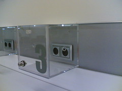
In my recent talk at LIFT, I used a photo of electrical outlets in public spaces denying their public use to highlight the issues around the ownership of the infrastructure providing ubiquitous experiences. I wanted to suggest that it does not mean that the infrastructure is out for us to profit from it. In other words, access has often a cost (financial, proper devices, privacy, time, …). In the meantime I spotted this beautiful transparent box at the Espacio Movistar that prevent people to get access to plug their electric devices unless that have a key. It reminds me of some fast food restaurants in Switzerland in which customers need to ask for the key or codepass at the counter to get access to the restrooms.
To further exemplify my thoughts, it seems that the increase of mobile devices in need for power has become a problem and a business opportunity in some airports.

Does the Dallas/Forth-Worth airpot set the standard by now providing pay-per-use electricity?
Relation to my thesis: the constraints to seamlessness
Posted: March 7th, 2007 | No Comments »
I have been enjoying Mika Raento‘s works since his Symbian Hacks for Context-Aware Programming that helped me a great deal on some projects. Since then, Mika has been working (among other things) on Jaiku. As one of the top mobile ubiquitous application developer out there, Mika keeps track of his frustration on the technologies and platforms that do not deliver the expected quality. For example he has been highlighting the issues on building IP-based application on top of 3G/UMTS
3G/UMTS is nowhere near working! Moving around in central Helsinki, an E61 drops the network fully or switches between 2G and 3G (dropping TCP connections) every few minutes. Establishing calls may take 5 tries.
Moving outside central urban areas, an N80 will constantly try to connect to a 3G cell, fail, connect to a 2G cell, notice there’s a 3G cell available, try to connect, fail, repeat. The phone heats up and kills the battery in about an hour.
Sending a few packets of data every few minutes kills most phones’ battery in about 8–12 hours on 3G. The same amount of traffic per time unit on 2G (GPRS) allows 2–3 days of use.
So neither the network nor the GSM chipsets is up to the task yet. I think the people pining for 3G at the moment are not actually using it for anything real.
In a recent talk, he mentioned his problems of using TCP as part of a solution to provide Jabber fro Jaiku:
The trick, is that the “reliability’’ this documents talk about is quite different with what we tend to think of as reliable. TCP’s reliability means in-order delivery and integrity (no bits flipped). What people often think when they think of reliable is some vague idea of “data getting to the other end’’. Which of course isn’t the case.
Relation to my thesis: Mika provides a timely down to the ground really check on the development of mobile, context-aware applications. Yes ubicomp is here, but it often gets down to the science of “bricolage”?
Posted: March 5th, 2007 | No Comments »
My paper for the Pervasive 2007 Doctoral Colloquium has been accepted. It is an extended version of the CHI’07 submission.
Bridging the Social-Technical Gap in Location-Aware Computing
Abstract. Building ubiquitous applications that exploit location requires integrating underlying infrastructure for linking sensors with high-level representation of the measured space to support human activities. However, the real world constraints limit the efficiency of location technologies. The inherent spatial uncertainty embedded in mobile and location systems constantly challenges the coexistence of digital and physical spaces. Consequently, the technical mechanisms fail to match the highly flexible, nuanced, and contextual human spatial activities. These discrepancies generate a social-technical gap between what should be socially supported and what can be technically achieved. My research aims at exploring, and hopefully reducing this gap in the context of location-aware computing.
Relation to my thesis: I am pretty glad that people like Shwetak Patel (Supporting Location and Proximity-Based Studies in Natural Settings) and Leif Oppermann (Extending Authoring Tools for Location-Aware Applications with an Infrastructure Visualisation Layer) will also present their work. Hopefully Leif will also talk about his location based mobile phone game Love City. Pervasive 2007 will take place on May 13-16 in Toronto, Ontario, Canada.
Posted: February 27th, 2007 | 3 Comments »
The Amgen Tour of California took place this week. During this year’s edition, 7 riders have been tagged with CSC’s OmniLocation devices to send a constant stream of GPS data to the T-Mobile GSM network (over general packet radio service signals, HTTP streaming and SMS messaging). In consequence, The race’s web spectators had access to almost-real-time location information displayed on Yahoo! maps for the riders with a short delay offset (i.e. about 10 seconds).


Screenshots from the live webcast featuring the rider tracking system.
Relation to my thesis: Using sensors to track performances in sport is nothing new. Yet, this is an example of deployment in a semi-uncontrolled settings (the GSM network provider was a sponsor). Moreover, I am wondering about the web spectator’s experience in watching dots moving (without smooth animation but with icons of riders jumping from one location to another) on a map. Finally, the web application does not seem to take into account the delay offset from the acquisition of the location to the display on the screen. I suspect that a sharp synchronization of the geodata had to be performed prior to the visualization.
Posted: February 27th, 2007 | 1 Comment »
Artist Aram Bartholl has performed a couple of compeling locative media projects. In Plazemark he connects places painted with 2D-Codes with Plazes. Lately, he has been building and deploying physical dots of Google Maps (movie) and Plazes.


Relation to my thesis: we know how to augment the physical space with virtual information… what would happen if this virtual information could get fabjectized?


