Posted: January 20th, 2007 | No Comments »
I have been playing around trying to sketch a literature map of my research. Here is the current high-level status.

If I ever need to theorize more my framework, I still keep situated action, embodied interaction and distributed cognition in the drawer.
Posted: January 19th, 2007 | No Comments »
Suomela, R., and Lehikoinen, J. Taxonomy for visualizing location-based information. Virtual Reality 8, 2 (2004), 71–82.
This paper concentrates on analyzing different visualizations for location-based applications. It studies two factors that affect the visualization of location-based data. The two factors are the environment model they use, ranging from three dimensions (3D) to no dimensions (0D) at all; and the viewpoint, whether it is a first-person or a third-person view. The authors suggest a taxonomy featuring model-views (MV) for visualizing location-based data.
The environment model is used to denote how many dimensions the application uses in visualizing the environment. If no environment model is used, the user does not gain specific location information of an object, except that the object might be somewhere close by.
- 3D environment model: these applications have an accurate 3D model of the environment and they place the location-based data onto its actual location in either the virtual or augmented view
- 2D environment model: the locations of the virtual objects are accurately projected onto a plane
- 1D environment model: application only shows one aspect of the location-based data
- No environment model: the applications present the data to the user but nothing about its location or relation to the user
The user’s view to the location-based data is one of the two:
- First person view: the user views the location-based data from a user-centric view, and the location-based data is spread around him or her
- Third person view: the user views both the location-based data and his or her representation
The first-person views, MV(x, 1), can help the user in wayfinding and provide additional information on objects. It is easy to show where the next waypoint is or the direction to it, and all visible real-world objects can be digitally augmented with additional information. The third-person views on the other hand can show the user a much wider area in all the directions around the user, as they are not restricted to the user’s current viewpoint and orientation.
Navigational tasks and views
For some tasks, the egocentric views are better, while for other tasks, some other views would be preferred. Navigational tasks with digital maps can be defined as searching tasks (naïve search and primed search), and exploration tasks. A fourth task can be defined as a targeted search. In a targeted search, the target is shown on the map; in primed search, the target is known, but does not appear on the map; in naïve search, there is no a prior knowledge of the position of the target, and the target is not shown on the map; in exploration, no specific target has been set.
Alignment
An important aspect concerning maps and navigation is alignment; that is, it specifies how the map is oriented with respect to the user and the environment. A map may be reader aligned, in which case the orientation of the map remains constant with regard to the reader’s body. An environment-aligned map, on the contrary, is oriented consistently with regard to the environment; in other words, north on the map always corresponds to north in the environment.
People difficulties in map reading
Even though a 2D map display is a well known visualization technique, it has been found that the most severe problem with
using traditional 2D maps is the inability to understand the spatial relationships between the real-world objects, and, therefore, to match the map and terrain model in one’s mind (a study shows suggests that up to 64% of the population have difficulties in map reading.
Models and location accuracy
Not all of the models need similar accuracy for the location. The AR applications need to determine the user’s viewpoint very accurately, as they need to know how the real world is aligned to the user. On the other hand, applications that only list the virtual objects do
not need to know the location very accurately.
Examples from the taxonomy
3D environment model: first person view; MV(3, 1)

3D environment model: third person view; MV(3, 3)

2D environment model: first person view; MV(2, 1)

For example, car navigation system
2D environment model: third person view; MV(2, 3)

The application only needs to know the user’s location; other sensor information is not necessary. Increasing the map scale can compensate for an inaccurate location of the user, but if the user’s location is not know accurately, there is no point in showing “You Are Here”. Previous studies have shown that a map is easier to use if it is aligned forward up.
1D environment model: third person view; MV(1, 3)

Relation to my thesis: The authors mentions the relation between the model and accuracy to position the user’s viewpoint. Yet, they suggest that virtual objects do not need to be perfectly located. If the hardware does not have accurate sensors, the third-person views might be more user-friendly. This still has to be studies and proved. Moreover, they mention that “location-based information is, typically, a set of virtual objects in a certain area, and that virtual object have a precise location in the real world”. I do not agree about virtual object having a precise location, when one think for example of Flickr geotagged images attached to the an area (i.e. a place) and not a position. Many times, an area does not have clear limits such as walls and people have different perspective of an area.
The model lack of the time dimension, since virtual objects are not necessarily fixed.
Relevant reference:
Aretz AJ (1991) The design of electronic map displays. Hum Factors 33(1):85–101
Posted: January 19th, 2007 | No Comments »
Borriello, G., Chalmers, M., LaMarca, A., and Nixon, P. Delivering real-world ubiquitous location systems. Commun. ACM 48, 3 (2005), 36–41.
This paper emphasize on the practical aspects of getting location-enhanced application deployed on existing devices without installing special infrastructure. It provides an overview of different types of ubiquitous location system. Based on two case studies, the authors reveal some interesting issues in the deployment of location-aware systems such as:
Edinburgh is an old city with many narrow streets and high buildings; its latitude of 55° north—almost as far north as Alaska—accentuates the urban canyon effects that hamper GPS.
[...]
On average, one or more access points were detected 48% of the time, and Place Lab could provide an accurate location. Two or more access points were detected for only 22% of the time. Indeed, the overall detection rate increased from 48% to 69% when excluding period of time visitors appeared to be indoors.
[...]
The game designers were surprised, for example, that rain, snow, and leaves on trees strongly affect WiFi and GPS.
[...]
The transfer of packets to and from access points can show significant asymmetry, and high packet loss can occur despite apparent network access.
Even if not standing in opposition to research aimed at improving accuracy and broadening availability, the authors suggest that we should offer pragmatic solutions while we continue to improve, adapt, evaluate the underlying technology of ubiquitous location systems.
Relation to my thesis: A reference I can use in a position paper for the workshop on Common Models and Patterns for Pervasive Computing to highlight the issues of deploying a WiFi-based location system such as CatchBob!. Besides the issues and challenges mentioned in this paper, I will add (among others things) the the uniqueness capabilities of pervasive devices.
Posted: January 18th, 2007 | No Comments »
Hazas, M., Scott, J., and Krumm, J. Location-aware computing comes of age. IEEE Computer 37, 2 (2004), 95–97.
This introductory paper to Location-Aware Computing talks about the numerous location-sensing systems that differ with respect to accuracy, coverage, frequency of location update, and cost of installation and maintenance. The authors devid them into coarse-grained and fine-grained systems.

Many similarities with A Survey and Taxonomy of Location Systems for Ubiquitous Computing.
Relation to my thesis: Which coarse-grained and fine-grained location-sensing systems ought to be used to match the location information granularity expected by a user on a specific activity. I am interested in granularity not only based on accuracy, but also in terms of timeliness.
Posted: January 18th, 2007 | 3 Comments »
Bell, G. and Dourish, P. In press. Yesterday’s Tomorrows: Notes on Ubiquitous Computing’s Dominant Vision. Personal and Ubiquitous Computing.
In this article, the authors advocate for developing a “ubiquitous of the present” which takes the messiness of everyday life as a central theme. The argumentation is organized around three framing points: ubicomp is already here, but does not have the form we envisioned, the futurist vision of ubicomp allows researchers for responsibilities for the present, and ubicomp is inherently messy.
Ubicomp is present
Ubicomp is essentially defined by its vision of a technological future. The literature carries the idea the ubicomp research is exploring prototypes of tomorrow’s everyday technology and everyday experience is a pervasive one. However, when we look outside of the research laboratory (based on 2 case studies in Korea and Singapore in this paper), the author look at ubiquitous computing. They argue that ubicomp is already here; it simply has not taken the form that we originally envisaged and continue to conjure in our visions of tomorrow.
The vision as excuse
The framing of ubicomp as something yet to be achieved allows researchers and technologies to absolve themselves for responsibilities for the present; the problems of ubiquitous computing are framed as implementation issues that are, essentially, someone else’s problem, to be cleaned up afterwards as part of the broad march of technology.
Ubicomp is messy, seamlessnes is a misleading vision
The seamlessly interconnected world of future scenarios is at best a misleading vision and at worst a downright dangerous one. [...] Dealing with the messiness of everyday life should be a central element of ubicomp’s research agenda. In practice, though, we see that infrastructures are continually visible and must be consciously attended to in the course of everyday encounters with ubiquitous computing, from the vagaries of network access to the structure of service billing. [...] Infrastructures remain messy after decades or centuries, as the user of any transit system from urban subways to international airlines can attest. [...] The crux of her approach is to look at infrastructure as a relational concept; an infrastructure is an infrastructure only from the perspective of specific peoples and technologies. [...] In other words, infrastructures are messy. The messiness that we experience in laboratory ubiquitous computing infrastructures is not a property of prototype technologies, of the bleeding edge, or of pragmatic compromise; messiness is a property of infrastructure itself. Infrastructures are inherently messy; uneven in their operation and their availability. [...] Mobile telephony, after all, offers widespread coverage, but is neither truly ubiquitous nor truly seamless; incompatible standards, spotty regional coverage, etc., seem like obstacles that we must still overcome before the ubiquitous computing vision can be realized. But postulating a seamless infrastructure is a strategy whereby the messy present can be ignored, although infrastructure is always unevenly distributed, always messy. An indefinitely postponed ubicomp future is one that need never take account of this complexity. [...] Infrastructures, then, be they networks of car mechanics, medical categories, or power sources, are never seamless in the ways in which they are put to work. They are sites of negotiation and contest, compromise and coordination, approximation and partial agreement. They are unevenly distributed and unevenly available. They are continually in flux, and brought into local stability only through active engagement and coordination. Infrastructure itself is a relational property; it describes a relationship between technology, people, and practice. [...] It is not merely a dream of a world not yet realized; it is a dream of a world that could never be realized.
Relation to my thesis: The observation of ubicomp as inherently messy is at the core and a trigger of my research. Ubicomp literature mainly contain studies and prototypes embracing the seamless utopia. I wrote my paper Getting real with ubiquitous computing: the impact of discrepancies on collaboration partially in reaction to the “perfect-world” expectations around ubicomp. Weiser’s humanist vision did not fit at all my observations during the CatchBob! experiments. Bell and Dourish they take a very similar perspective as Adam Greenfield in Everyware claiming that ubicomp is here. This is probably something that was missing in my paper. I failed to notice the arrival of ubiquitous computing is rooted (at least in part) because it has been so much rooted around the idea of seamless interoperation and homogeneity.
Posted: January 18th, 2007 | 1 Comment »
Based on their first experiment to Visualizing the Crowd’s “Mental Map” Using Flickr Geotagged Images, Yahoo! Research Berkeley has now introduced their TagMaps toolkit with a sample applications (World Explorer, Night Explorer and Trip Explorer). The size of the tags reflects their importance. The bigger the tag, the more “important” for location and the given zoom level, tag frequency, uniqueness, user identity and social factor.

World explorer in Barcelona
Relation to my thesis: An example to reveal user-generated location information. The Night Explorer takes into consideration the timeliness of the location information.
Posted: January 18th, 2007 | 1 Comment »
Jan Chipchase has post on a remote control to operate the toilet with peace-of-mind-security coverage placed next to the toilet interface. So when house guests are wanting to flush and aren’t familiar with these interfaces it is no surpise that the ‘wrong’ button is pressed and an alarm sounds, and the security company sends out a uniformed emergency response team. There is of course many wrong approaches in this future-perfect-connected world situation. Yet, it reminded me of the thoughts of Adam Greenfield on the the blue toilet of death highlighting the coexistence of systems surrounding us and their nonlinear interactions and the affective dimensions of system failure (advocating for “graceful degradation”).
And still nobody was talking about the nonlinear interactions of network systems in one space all operating at once – it’s as if none of the people who were designing them had, not so much thought, but felt what it would be like to sit in the middle of a room where you’ve got fifteen different technical interfaces around you, and you’re responding to all of them at once, and they’re all responding to you at once.
[...]
But I’m not sure how many people in academic ubicomp have really marinated themselves in a consideration of the experiential and affective dimensions of system failure. I’m not sure to what degree people have ever simply sat and imagined what it will feel like when systems like these surround us…and break down, as technical systems often do. They may have thought about the specific system at hand, but as a gestalt? I haven’t heard that many people raising the issue.
These kind of problems are exemplified by Fabio Sergio and his story with motion sensors in a bathroom and considerations on reactive system as well as by Mark Meagher on automatic doors and how the funtionality of the door are invisible and no attempts are made to communicate to the user.
I enjoy observing people (and myself) waving my hands in front of a tap or to an automatic doors. Doors in swiss train are particularly prone to the situations described by Mark. Their opening is often slow, maybe due to the overuse of the sensors or most probably to their bad calibration. Some train have sensor on the floor (opening when you step in). It is not unusual to see people jumping or hardly stepping in front of the doors. Other trains have their sensors in the top and bottom of the door. I noticed that even some train directors do it and some people refusing the automation and manually forcing the door to open. I am wondering if there is ever been a study a user-centered study to calibrate the swiss train automatic doors to lower the user confusion.
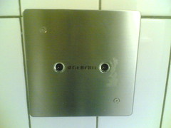
Geberit’s eyes, motion sensor in a bathroom
Relation to my thesis: My work highlights to problem of integrating technological limitations (such as system not being able to coexists) and human factors in real-world environments. I already mentioned it in Peaceful Cohabitation and Scalability in Ubicomp. I am exploring how to support user activities top of errors and system-generated uncertainty. In the context of interaction, I guess it is not only important for interfaces to reveal their functionalities and states, but also to think in terms of granularity (for example to calibrate thee automatic doors) as express by Mike Kuniavsky.
Posted: January 17th, 2007 | No Comments »
Ed Parsons posted a short report of the couple of days he spent at Reuters, as part of their excellent Innovation Programme. He mentions the increasing interest for Reuters to deliver location and consumer focused information but as with many things maybe it will take at least three or four attempts for location based services to reach the mainstream. The challenges to deliver appropriate LBS (e.g. data availability, privacy concerns, standards). However, Reuter’s interest show the intention to innovate in the long term in this space.
Relation to my thesis: In the past, location information where given by official or central entities. The bottom up generation of geolocated information raises not only the problem of lack of standards but also on the granularity (or generalization) and the subjectivity of the location attached to the information. Similar challenges faced by GeoCommons for example, that companies such as Urban Mapping try to tackle.
Posted: January 16th, 2007 | 1 Comment »
Since I last used GeoIQ to create my heatmaps on the usage of the accuracy feature in the Flickr geottaged images, Fortiusone has been busy developing an moving from Google Maps to KML as well as setting up a repository for shareable geospatial called GeoCommons. Besides uploading and downloading data from GeoCommons, users will be able to take their data and anyone else’s in GeoCommons and make a mashup with GeoIQ heat map generator. FortiusOne founder Sean Gorman provides a compelling proof of concept in the company’s blog with a mashup of highly rated bars and single women in Manhattan.

Relation to my thesis: GeoIQ has been a great tool to quickly get heatmap viz of some of my geodata. Their GeoCommons might be an excellent opportunity to explore more the levels of granularity used when people share geodata. In the context of GeoCommons, I am also interested to observe how the accuracy and veracity of the data is handled. It is I guess one of the challenge of such a collaborative platform.
Posted: January 10th, 2007 | No Comments »
I took the opportunity of the upcoming LIFT open stage session to propose a talk on technology and messiness, a subject related to a philosophical aspect in my research that highlights the mismatches between our needs, expectations and behaviors towards technologies.
Embracing the real world’s messiness
Description: Science and engineering aim at improve and facilitate our lives. However, multiple physical, economical, organization and social constraints challenge technologies to seamlessly provide well understood services. Unlike often advertised technologies do not lead us to live in harmony with quiescent and stable systems. Indeed, to live in our everyday world, systems must always be maintained, and our relationships to them must be continually negotiated. The increasing complex integration of technologies in our digital lives and cities further highlights new types noises, failures and annoyances, as the user of any international airport or mobile wireless service can attest. This talk will raise these issues by exemplifying the messiness inherent to technologies.
Update: Presentation of the talk proposal on the LIFT07 blog.
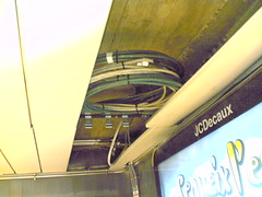

The messiness around us… (the nests of cabling barely hidden in the dropped ceiling)


