Posted: November 3rd, 2009 | 1 Comment »
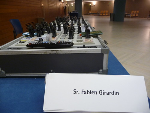
Last week I was at Donosti-San Sebastian, to give a short presentation of my research at the The First International Conference on the Measurement and Economic Analysis of Regional Tourism. In the session, “New Instruments for Measuring and Modelling Tourism Flows”, I delivered my classic spiel “Analysis of Visitors from their Digital Activities” that covered:
- the ability to reveal aspects of visitors experience of a city/region from their digital activities
- the opportunities to evaluate urban strategies
I have added some notes and references to augment my slides.
Prior to my talk, Carlos Arce provided a complete scan on the new instruments and techniques to measure travel behaviors, mentioning the battles in persuading people and organizations to participate to survey and the necessity to “sell better” the value of these kind of analysis (impact, opportunity and efficiency; for special need population or special areas (eco-tourism)).
Following the other presentations, it seems there are not many innovations that can surpass the power of paper+pencil to measure travel behaviors. Back in the Simpliquity days, we inspired from this traditional technique to develop a very simple technological solution for Detecting air travel to survey passengers on a worldwide scale. This approach contrasted with the quest for perfect data some statisticians seem to lose themselves in, some requesting a mandatory Galileo reporting system for each vehicle in function in the EU. I mean, Europe can be more creative than that! Fortunately, some statisticians do not seem well-armed with a consistent argumentation to get what they do not have, considering the barrier they already face (privacy, propriety, silos, data quality, evaluation of their models). I particularly expected to experience more discussions on the transformation of measures and analysis into politics and strategies (and their evaluations).
Last week, Nicolas was also invited in a keynote address to discuss the near future of tourism services based on digital traces.
Señor!
Thanks to CICtourGUNE and particularly to Ibon for the invitation!
It seems our work has inspired others very recently: Explorando otras fuentes de datos: Flickr y el turismo and Redes sociales y turismo: flickr + Canarias.
Posted: October 30th, 2009 | No Comments »
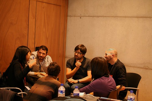
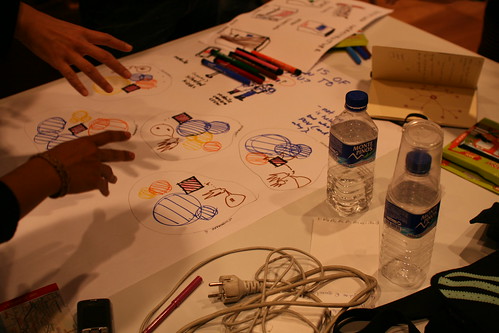
Last saturday at Citilab in Cornellà, in the outskirts of Barcelona, Nicolas and myself organized a “lift @ home” event during the Urban Labs days.
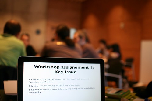
This one-day long workshop called “Hands on Barcelona’s Informational Membrane helped launch the Ciudad Percibida initiative and is part of a series of seminar about the new practices as well as the visions and issues around the hybridization of the digital and the physical in cities (upcoming November 9 in Geneva: Urban informatics / Les nouveaux paysages numériques). In this event, we focused on the informational membrane hovering over Barcelona and try to sketch near-future scenarios with datasets and infrastructures existing in city. The goal was to understand a contemporary urban software infrastructures and explore the implications (trade-offs, opportunities and concerns) in the data they generate. The effort was put on Barcelona’s specific issues (e.g. mobility, infrastructure, tourism, gentrification, ecology …) and their related datasets.
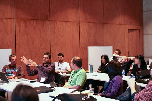
We had a group of 30 participants coming from very diverse backgrounds: designers, engineers, people from the city of Barcelona, ethnographers, architects, etc. both from the area and abroad. We started from a presentation&discussion about the general problems of Barcelona and the available data. Then small groups have been formed to work on how to use the existing infrastructures and data to create potential solutions in terms of services. The assignments led people to go beyond traditional techno-determinism to envision social and organizational framing.
We’re working on a short write-up document for this workshop. Something that would summarize the findings and pave the way for upcoming seminars.
Posted: October 20th, 2009 | No Comments »
On Saturday October 24, Lift lab will run the workshop “Hands on Barcelona’s Informational Membrane” at Citilab in Cornellà (Barcelona) in the last day of Urban Labs. Our first workshops that aimed at discussing the new practices (see Round table on Real-Time Cities at MIT) and the visions and issues (see The Design of the Hybrid City of the Near Future at Lift09) behind the concept of hybrid cities. This time, we will try to go beyond abstract discussions and far-fetched visions. The 25 participants will focus on the informational membrane hovering over Barcelona and try to sketch near-future scenarios with datasets and infrastructures existing in city. The goals will be to understand a contemporary urban software infrastructures and explore the implications (trade-offs, opportunities and concerns) in the data they generate. With Nicolas Nova, we will use these upcoming days to finalize the format of the workshop, but we will make an extra effort to ground it on Barcelona’s specific issues (e.g. mobility, infrastructure, tourism, gentrification, ecology …) and their related datasets.
Once again, we are particularly proud with the mix of talents and pioneers that will join us.
Prior to the workshop, Adam Greenfield will present his takes on networked cities and hopefully also provoke us on the data networked object generate (see Toward urban systems design). Following-up on the same theme, Ben Cerveny will most certainly take some altitude to discuss design research on urban computational systems (see VURB). We could not think a better pair of inspiring speakers to provoke the rest of the participants who for the main part, are pioneers practically involved with the concepts of digital/hybrid/data/networked/sentient cities:
Mario Ballesteros, independent editor, researcher who I met in his role of curator for the Design Hub in Barcelona, is a regular collaborator at Actar Publishers and writes in his own personal research blog, Mañanarama, on the subject of modern architecture in Mexico as a product of failed development.
Joan Batlle, the Head of Innovation and eGovernment International Cooperation Department of the Barcelona City Council, has been leading many projects applying innovative Technology in government processes, including the Intelligent Cities of the Next Generation project.
Anjalika Bose, working currently in Philips Design Probes, as an Ambient Experience Designer, pushing projects in the realm of architectural spaces (see Design Probes).
Cariou Christophe, an independant researcher and founder of Everydatalab who I met at the World Information City conference where he presented an innovative process of mixing quantitative data (anonymous logs of calls, handovers and sms) with user-generated content to map the Fête de la Musique night in Paris.
Jose Luis De Vicente, a cultural researcher and curator. He directs the Visualizar program at Medialab Prado, Madrid.
Domenico Di Siena, architect and researcher, has been reporting his exploration of the relationship between public space and new technologies on Ecosistema urbano and urbanhumano. He is also actively involved in the development of the Meipi collaborative platform.
Juan Freire, PhD in Biology and Professor at the University of Corunna (UDC) where he acted as Dean of the School of Sciences. Now, he is CEO of Fismare, an environmental consulting firm, and fellow of e-Cultura, a firm devoted to cultural management, territorial development and creative processes. I particularly discovered the uniqueness of Juan at Visualizar when he wore his marin biologist hat and drew comparisons between the ocean and urban environment.
Paco González, architect, works and researches at radarq.net, an open study which works and researches on architecture, city and network (see their projects).
Irene Hwang, an architect and editor, co-founder of Constructing Communication. I met Irene in her role of curator for the Design Hub in Barcelona.
Daniel Kaplan, founder and CEO of the Next-Generation Internet Foundation (Fing), a collective and open Research and Development project that focuses on digital innovation and on the interaction between technological progress, business innovation and societal change
Giles Lane, an artist, researcher and teacher, founder and co-director of Proboscis that has widely been inspiring research in locative media and ubiquitous computing since 1994 (mine included), particularly for their capacity to act on the field with citizens and institutions as well as their creative practice that mix fields as diverse as medical research, music, community development, housing and urban regeneration, pervasive computing, mapping and sensor technologies.
Joachim Neumann, researcher at Telefonica Research who has been developing some unique analysis of the Bicing bike-sharing system in Barcelona (see Sensing and Predicting the Pulse of the City through Shared Bicycling)
Thierry Marcou, director of the Villes 2.0 program (e.g. workshops with citizens and local institutions) that led to the development of the Green Watch / Citypulse platform that encourage people’s implication in measuring environmental indices.
Andrés Ortiz, co-founder of Bestiario dedicated to data dynamic representation and to the creation of digital spaces for the collective creation of knowledge. A pioneer in making the complex comprehensible.
José Luis Pajares, designer and research at Univ. Carlos III de Madrid. He has been working on web interfaces web for location and context-aware mobile devices.”Gelo” also organized of the My Map is not your Map workshop.
Yuji Yoshimura, who I am at Barcelona Ecologia, is now an expert in urban mobility and environmental analysis at Center for Innovation in Transport in Barcelona.
Fortunately, we will benefit from the critical thinking of a couple of participants less involved in practical work on informational membranes:
Nurri Kim, artist and archeologist of the moment, who has recently opened Feeder in Helsinki. This exhibition presents a project dedicated to photographing people that I’ve made custom lunches for (including depictions of the meal that I cooked for them and what they would usually have for their lunch) from 2006 to the present.
Rosa Pera, director of Bòlit, Centre d’Art Contemporani. Girona and director of the master degree “Directing and Designing Exhibition Projects” at Elisava School of Design in Barcelona.
Last but not least, I look forward to meet for the first time Albert Cañigueral, Mathieu Favez, Chris Pinchen, and Lillian Shieh!
Why do I blog this: We hope that this workshop offers an alternative venue to the now omnipresent corporate discourses on self-proclaimed “Smart Cities” and government initiatives on “Open Cities“. With its practical approach, anchored on a specific urban context (i.e. Barcelona), this workshop aims at exploring the implications behind these kinds of initiative, understanding what resources are available and their potentials to improve/prejudice near-future cities. Other similar approaches include Dan Hill’s Urban Sensing course and the upcoming Sentient Rotterdam workshop.
Posted: October 16th, 2009 | 1 Comment »
Idealista has been developing its business in offering the classic online real estate ads platform. The massive amount of information they have been accumulating over the years is transforming them into an urban actor, offering their analysis of the evolution of the real estate market back to the public as well as trends almost in real-time (e.g. el precio de la vivienda usada en españa ya está en niveles de 2005); the kind of report that would take longer to produce through traditional processes. Not only do the analyze the market from the offers (online ads) but they could also evaluate the demand in certain areas of a city from logs on their web server. All this accessible back to the public through their open API.
Now, Idealista offers a call-free number for housing seekers to report any “for rent” or “on sale” sign on the street. If the real estate object is in their database, they will provide all the descriptions and possibly offer the kind of comparative service (i.e. comparing the price with the market) they offer online.
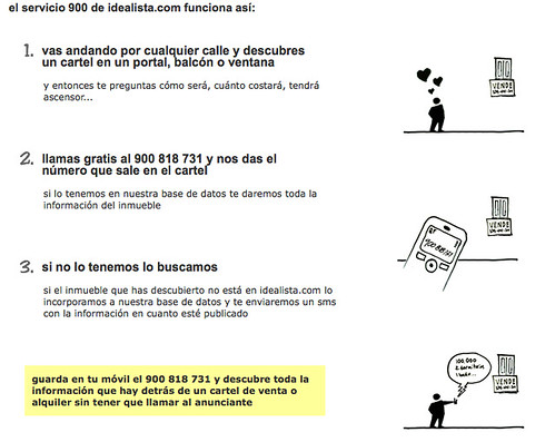
Why do I blog this: Some food for thought for our upcoming workshop ‘Hands on Barcelona’s Informational Membrane‘: An online service, accumulating data on a city transforming into an urban actor, now using crowdsourcing techniques to expend is coverage. Curious to see how this evolves.
Posted: October 13th, 2009 | No Comments »
This blog is now a 6.5 years ‘note to self‘, and will continue so. It contributed to help me frame and polish my thoughts on my research, and will continue so.
Now, A PhD behind me, and Lift lab in front of me, I have paved my next steps, communicating the results of my research and forging new non-academic alliances, to the detriment of contributing blog. Now that my “voice” related to the contributions of my thesis needs a renewal, I am back to a Making/Creating/Building phase (see The Kind of Research I am). I am spending a good share of my time, slightly away from this blog, developing processes and tools to qualify, measure, find utility and extract value from captured urban dynamics. It means moving beyond the fascination around basic capacities to sense or visualize a city in real-time. It means, being humble, working on the ground, understanding clients and partners, their practices and how new tools and techniques can integrate their traditional processes. It means confronting and plotting with bounded disciplines or as Julian Bleecker would say:
“Let things get rather undisciplined and a bit unruly. Disciplines are self-satisfied, with is akin to apathy, which never solved any problems.”
Back to the Making/Creating/Building Phase, contributing on two levels: 1) software/process modeling (making/creating/building); 2) talk planning (polishing a discourse)
Posted: October 13th, 2009 | No Comments »
As part of a conference-debate on “La Terre Vue du Web” organized by Joaquín Keller and Christel Sorin, I gave a talk entitled “Pratiques des nouveaux espaces numériques” (slides in French) to present and debate on the emerging presence of geoinformation, often issued from the Web (expended definition of the Web that includes web protocols and Web of Things) and their implications on contemporary practices in the city. Based on a previous talk, I highlighted the ability to perform a new type of urbanism, based on evidences, merging traditional survey techniques that observes and counts the visible with now developed web analytics tools that measure activities online. This “evidence-based urbanism” provides new means to evaluate and improve strategies, exemplified by our analysis of the digital activity at the New York City waterfront as indicator of urban attractiveness (see study of the New York City Waterfalls).

New practices: merging techniques and tools to observe and measure the urban and the web, the visible and the invisible.
On the other hand, the digital representation of the physical is imperfect and potentially misleading. For instance, satnav system augment our wayfinding capacities with instantaneous contextual and planning information. Taxi drivers must assess and learn their fluctuating quality that must be assessed, leading to an evolution of their practice, sometimes amputating the capacity to learn directly from customers advices.

Evolving practices: assessing the quality of the geoinformation
The debate covered several aspects around the capacity to manipulate previously inaccessible datasets (see From Shoeboxes to Digital Footprints and Digital Shadows, Citizens to Improve Bicing, …), their ability to represent/disform the truth, the use of “sexy” visualizations as part of a research process (see Below the Tip of the Urban Data Iceberg), and their integration into current practices (see Why Real-Time Data Are Not Used to Improve Urban Systems?)
Thanks to Joaquín Keller and Christel Sorin for the invitation!
Posted: October 5th, 2009 | No Comments »
This week, I head to Paris for a gig at La Cantine on the theme “La Terre vue du Web“. I will team-up with Denise Pumain to discuss the ways information, communication and location-aware technologies change our relation with the space. This event is part of a conference series on interdisciplinary approaches to the Web.
Later this month, Lift lab will run a workshop in Barcelona “Hands on Barcelona’s Informational Membrane” that aims at exploring the implications and opportunities of the presence of the informational membrane hovering over Barcelona. The list of participants is already utterly promising.
Finally, I will mingle with tourism professionals and experts at the First International Conference on the Measurement and Economic Analysis of Regional Tourism in San Sebastian, presenting new instruments for measuring and modelling tourism flows and other types of innovation in the tourism enterprise. After the 9th International Forum on Tourism Statistics at OECD, I am thrilled to once again participate to a conference sponsored by the UNWTO with practitioners and people who perform studies on the field.
Back on the road again
Why do I blog this: Thriving from the rich diversity of contiguous domains, languages and perspectives.
Posted: September 24th, 2009 | No Comments »
Today I participated to the My Map is Not Your Map Workshop at Arteleku in hype and laid-back San Sebastian. The workshop gathers an enriching mix of artists, designers, academics, engineers. My 45min talk “New maps and practices of hybrid spaces” aimed at describing the new types of maps of hybrid spaces, their utility and their integration into practices from tourism and urban studies to the wayfinding practice of taxi drivers. Comparing to traditional maps, I stressed the increasing value of the 4th dimension (time) in the dynamic and interactive representation of hybrid spaces now available, taking the occasion to provoke the audience with the notions of “real-time awareness” and “end of the ephemeral”. Indeed, not only these new maps alter our immediate apprehensions of the space we feel, live and work in, they also serve as means to communicate evidences and measurements, critical to evaluate space management strategies and policies. These approaches could alter the practices that relate to physical character of the world and human activities. However, part of the evolution of these new practices, we should consider their implications in forms of trade-offs and amputations.
The audience reacted to the notion of “imperfect mirror to reality” (information granularity, spatial uncertainty, seamful design), I believe capturing quite well the limitations of the kind of work I develop. I like to use these practical aspects, around the notion of oligopticon to balance any rhetoric that portrays the “perfect surveillance system”.
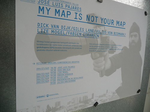
Thanks to José Luis Pajares for the invitation!
Posted: September 17th, 2009 | No Comments »
The First International Forum on the Application and Management of Personal Electronic Information will take place next month in Cambridge, MA. It is part of the Engaging Data initiative recently launched by the MIT SENSEable City Lab which seeks to address the issues surrounding the application and management of personal electronic information. The goal of the forum is to:
To explore the novel applications for electronic data and address the risks, concerns, and consumer opinions associated with the use of this data. In addition, it will include discussions on techniques and standards for both protecting and extracting value from this information from several points of view: what techniques and standards currently exist, and what are their strengths and limitations? What holistic approaches to protecting and extracting value from data would we take if we were given a blank slate?
The event will gather participants from multiple domains, including watchdogs and activists (see Program and Speakers), to debate on the major challenges of exploiting personal electronic information (e.g. Mining the network, extracting social value from personal data, best practices and standards, understanding the benefits versus expectations of users, …).

Why do I blog this: Lift lab is setting up a workshop for the Urban Labs gathering on the similar issues, with a practical focus, grounded on concrete projects (i.e. concrete datasets, concrete space of action, concrete actors). Beyond its many merits, I find the name of the “Engaging Data” initiative rather misleading, as we need to go beyond the stage of using data to engage. Taking the parallel with the many open data initiatives, after a rather short period excitement, there is now a need to measure the utility of exploiting these data (see Mesurer les résultats de la libération des données). Indeed, beyond the necessity to agree on the best practices, from transparent processes to the data protection, obfuscation and cloaking techniques, there will be soon a demand to prove their objective and subjective positive impacts (e.g. ROI, better awareness, improved services, improved public space design, quality of life). Now, the definition of criteria to measure this success is probably one outcome of the Urban Labs workshop.
Posted: September 9th, 2009 | 1 Comment »
The paper Detecting air travel to survey passengers on a worldwide scale (pre-editing version), co-authored with Pierre Dillenbourg and Nicolas Nova, as been accepted for publication in the Journal of Location Based Services. It reports on a methodology for gathering mobility data at a world-wide scale, contrasting with traditional travel survey methods. The originality of this research work is to take into consideration the limitations of the technological settings as well as the complexity of human and technological environments as the source of the design solution.
Abstract. Market research in the transportation sector is often based on traditional surveys, such as travel diaries, which have well documented shortcomings and biases. The advent of mobile and wireless technologies enables new methods of investigation of passengers behaviour that can eventually provide original insights into mobility studies. Because these technologies can capture travellers’ experience in context and real time, they pave the road for new surveys methods. In this paper, we demonstrate that mobile phones can recognize air travel with a light algorithm that scans their connectivity to cellular networks. The originality of our method is that it does not rely on any GPS-like location information and runs on a large variety of mobile phones. It detects flights on a worldwide scale and asks travellers to report on their travel experiences as they occur, eliminating the recall bias of traditional solutions. Once the system detects a journey, it triggers a flight satisfaction questionnaire that sends answers to a centralized server. This approach respects the traveller’s privacy and proved a 97% success rate in detecting flights in a 12-months study involving 6 travellers who boarded on 76 planes.
Keywords: Sensing and activity recognition, mobility detection, transportation study
Unlike the traditional ways to capture travel information, our approach relies on the mobile phone to generate “automatic passive” GSM fingerprints and trigger an in-situ questionnaire. It is an hybrid solution of implicit motion detection with the air traveller’s consent and explicit disclosure of the travel experience. The motion detection is based on an algorithm that analyses the sequences of GSM network Location Area Identity. The figure below shows 3 examples: In flight, the mobile phone roams from one country code to another. If our software does not retrieve any LAI within 30 minutes, it detects an air travel. In a train, the mobile phone moves within different network providers and area codes. No survey appears if the disconnection periods do not exceed 30 minutes. Similar scenario takes place for a car that moves within different location areas.

Why do I blog this: Work conducted a couple of years ago as a fruit of the research developed for CatchBob! at the demand of a client of Simpliquity. Unlike many designs that consider practical constraints as detrimental to the elegance of technological solutions, we instead viewed them as opportunities to rethink solutions which eventually have to change over time.