Posted: May 19th, 2006 | 1 Comment »
Developed by Adrian Herzog, MAPresso is a Java applet that creates cartograms and choropleth maps.

Example of world population under the age of 15 in 2003
Via Cartogtaphy
Relation to my thesis: Interested in cartograms and new ways to display spatial data.
Posted: May 18th, 2006 | No Comments »
Today and tomorrow I take part to a workshop on the Future of Web Search, held at the UPF Barcelona.
My good friend Mauro Cherubini will present his work on Mobile Search on Ubiquitous Collaborative Annotations of Space.
For credits in the doctoral school, I will need to write a paper on the very specific topic of Efficient Top-k Queries for XML Information Retrieval, that will be part of Gerhard Weikum‘s keynote speech
Abstract
Non-schematic XML data that comes from many different sources and inevitably exhibits heterogeneous structures and annotations (i.e., XML tags) cannot be adequately searched using database query languages like XPath or XQuery. Often, queries either return too many or too few results. Rather the ranked-retrieval paradigm is called for, with relaxable search conditions, various forms of similarity predicates on tags and contents, and quantitative relevance scoring.
The talk discusses recent advances and open research issues for ranked retrieval of XML data, and exemplifies them by the TopX search engine, a prototype system developed at the Max-Planck Institute for Informatics. TopX supports a probabilistic-IR scoring model for full-text content conditions and tag-term combinations, path conditions for all XPath axes as exact or relaxable constraints, and ontology-based relaxation of terms and tag names as similarity conditions for ranked retrieval. For speeding up top-k queries, various techniques are employed: probabilistic models as efficient score predictors for a variant of the threshold algorithm, judicious scheduling of sequential accesses for scanning index lists and random accesses to compute full scores, incremental merging of index lists for on-demand, self-tuning query expansion, and a suite of specifically designed, precomputed indexes to evaluate structural path conditions.
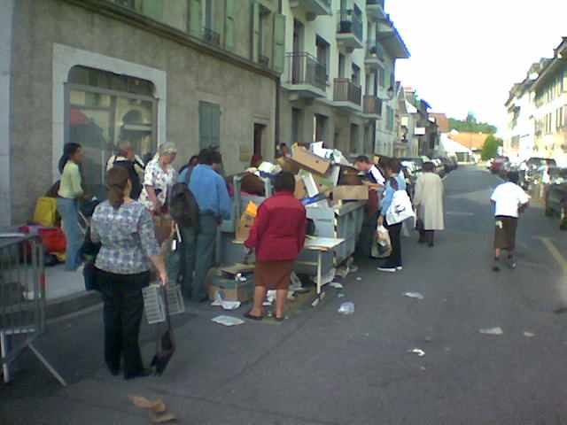
Posted: May 17th, 2006 | No Comments »
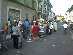
This container filled with carton boxes was a main attraction at one of Geneva’s flea market.
Carton boxes are crucial items that help us move and archive our lives. What are the digital carton boxes? USB sticks? Gmail accounts?
Posted: May 12th, 2006 | No Comments »

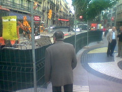
Related to: Gens qui Regarde les Chantiers
Relation to my thesis: Visible seams. Noticing the evolving physical space, is there a virtual counterpart?
Posted: May 11th, 2006 | 1 Comment »
I have presented my first “naive” models of spatial uncertainty in the context of ubicomp. There have been considered as a starting framework. While I should consolidate them, he mentioned that I should now provide a point of view. A simple one to start would be “what can we improve?”. This is probably the point of view I will take with the context of CatchBob! to submit a poster to UbiComp 2006.
Uncertainty induced by human interaction is not in the context of my work. Therefore he advised to mention in my model the excluded elements and, if the model gets too sterile, reintegrating them. I still need to take a stand on whether I should take into consideration a shared representation of location (i.e. location awareness in collaborative setting) or focus on the individual. A natural process for me would be to start focusing my models on the individuals and then enrich them with a collaboration perspective.
Starting from the model on location representation, I could investigate the dynamic of the interaction of the users with the representations and the space in the context of uncertainty. I never considered the ideas of evolution and dynamism.
He came up with the concept of “unavoidable errors” from numerical analysis and its inherence in computing.
Posted: May 10th, 2006 | No Comments »
MIT’s Carlo Ratti (from SENSEable City, they group behing Real-Time Awareness Maps of Cell Phone Usage gives an interview (Real-Time Maps May Create Better Cities) in Technology Review. He talks about the use of the real-time generated by the people’s use of radio-frequency beacons (GSM antennas, WiFi access points, …) to better understand the use of space. The rest of the interview is on privacy issues.
The answer to the question “How can people use real-time location data?” is a bit rough, and I surely would be interested to know more:
Carlo Ratti: This information becomes very interesting because it can create a feedback loop. When you give this information to the community, the community can change its behavior.
Relation to my thesis: I am interested in location awareness from the collection of sensed location to their collaborative use with an emphasis on supporting people in dealing with the “noise” blurring location data. The real-time feedback loop on spatial use mentioned by Carlo Ratti is truly new, and it is absolutely unclear on the how/what/when such information should be given to be useful (or at least armless). Nicolas’ work on CatchBob! surely cannot be generalized and scaled up, but it at least give hints on the complexity of location awareness mechanisms.
Posted: May 9th, 2006 | No Comments »
Motorola wants to patent “Method and apparatus for evaluating locations according to Feng Shui principles. Feng Shui is the Chinese practice of positioning objects, especially graves, buildings, and furniture, based on a belief in patterns of yin and yang and the flow of chi that have positive and negative effects.
The table with the chi values of each parameter is stored in phones memory and is used for calculation of chi values of different parameters.

via Unwired View
Relation to my thesis: Fusion of sensors (3D hall-effect sensor, digital camera, GPS (-> GIS database), microphone, AM/FM transmission strength and distance to towers) on a mobile device to change the perception of space.
Posted: May 9th, 2006 | No Comments »
Baecker, R. M., Grudin, J., Buxton, W. A., and Greenberg, S. 1995. Research frontiers in human-computer interaction. In Human-Computer interaction: Toward the Year 2000, R. M. Baecker, J. Grudin, W. A. Buxton, and S. Greenberg, Eds. Morgan Kaufmann Publishers, San Francisco, CA, 739-740.
This is a rather old article from the Human-computer interaction: toward the year 2000. book which predicted some areas that interest me:
Co-evolution and design for appropriation
Designing for human capabilities is challenged by rapid changes in environments that require mutual fit and adaptation of humans and computer.
The utopia in ubicomp
Finally, ubiquitous computing represents a profound shit in perspective. [..] Virtual communities, virtual reality, and ubiquitous computing, in particular, bring with them bright utopian and dark anti-utopian visions.
Relation to my thesis: Looking for some articles giving an overview of HCI to give a very high-level HCI context to my research.
Posted: May 9th, 2006 | No Comments »
Leonhardi, A. and Rothermel, K. 2001. A Comparison of Protocols for Updating Location Information. Cluster Computing 4, 4 (Oct. 2001), 355-367.
The location of information may be acquired by different types of sensor systems and therefore has different degree of accuracy. The transmission of location information can use different update protocols:
In case of a querying protocol the information is pulled by the receiver, while with a reporting protocol it is pushed by the sender. A combined protocol is also possible, where an optimal ratio between the number of updates and the number of queries has to be found.
The different types of querying protocols are:
Simple: the location information is queried from the source each time it is queried by the an application
Cached: the server stores a cached copy of the last transmitted location information
Periodic: the server queries the location information periodically from the source with a certain time interval D
The different types of reporting protocols are (the initiative is on the side of the source):
Simple: the source sends the location information each time the value has changed
Time-based: The location information is transmitted periodically after a certain interval of time T has elapsed
Distance-based: sends an update of the location information whenever the geographic distance between the current location and the last reported location becomes greater than a given threshold D.
Location and uncertainty model
A location sighting can have a temporal as well as a spatial accuracy. The temporal accuracy is given by the time that has elapsed since the location sighting has been acquired, while the spatial accuracy is de ned by the maximum distance between the position reported by the sighting and the actual position of the mobile object. For many location-aware applications the spatial accuracy of a sighting is more important, because the applications are concerned with the spatial relationship between (mobile) objects. The uncertainty ul(t) of a certain location sighting l describes the spatial accuracy at a given time t > tl.
At the time of the sighting the uncertainty is determined by the accuracy up of the sensor system. The uncertainty at a later time t can be estimated by the distance the mobile object may have traveled during the time t – tl. If a maximum bound for the velocity of the mobile object (vmax) exists, the maximum uncertainty of the location sighting can be calculated by adding the distance the object can have traveled to the uncertainty of the sensor system (see Figure 4). This is described by the following equation:


Tracking systems vs. positioning systems
The location information for a mobile object can be determined through various types of positioning systems. A basic distinction can be made between tracking systems, where a system of stationary sensors determines the location of a mobile object, and positioning systems, where the location information is determined by a sensor on the mobile object itself.
Disconnection and uncertainty
A common characteristic of these wireless networks is that a connection can be temporarily lost while the device is at an unfavorable location (e.g., inside of a tunnel), a state which is called a disconnection. In most cases a wireless network can also not o er as good a bandwidth and latency as a fixed networks (see [Sat96]).
In the following paragraphs we discuss the properties of the basic protocols with regard to disconnections, namely how long it takes to detect a disconnection and the maximum uncertainty of the location information returned during that time.
Location service functionalities
The location service shall provide the following functionality: It will support range queries, that is finding all mobile objects inside a given area, as well as position queries, which request the current location of a certain mobile object.
Relation to my thesis: Update protocols for location information can be used to reduce (or at least scope) uncertainty on the location timeliness. Catchbob! uses a time-based reporting protocol. On idea is to mix this protocols with others and have an adaptive approach depending on the connectivity and the stage of the game. I could also let the users choose their update algorithms and see their needs to change them. My try to contextualize update protocols in spatial uncertainty:

Posted: May 9th, 2006 | 1 Comment »

This centurey will be connected, monitored and smoke free… or won’t be. I am wondering when these signs will become default and therefore disappear.
Related: Deficient WiFi Awareness Sign