Posted: September 17th, 2008 | No Comments »
Previously accepted for publication in the Journal of Location Based Service, the paper Leveraging explicitly disclosed location information to understand tourist dynamics: a case study, co-authored with Filippo Dal Fiore and Carlo Ratti at the MIT SENSEable City Lab and Josep Blat my advisor at the Universitat Pompeu Fabra, in now available on the journal web site (Volume 2, Issue 1).
Relation to my thesis: First outcome of my collaboration with senseable. Follow-up work will be published in the upcoming issue of IEEE Pervasive Computing.
Posted: September 9th, 2008 | No Comments »
In November, I will be in Madrid to teach at this year’s VISUALIZAR workshop on “database cities”. Organized by Medialab-Prado, this series of workshop explores the social, cultural and political possibilities of the art and science of data visualization. This year, curator José Luis de Vicente set the focus on the city and its “daily generated volumes of information that requires new methods of analysis and understanding”. The introductory pitch goes as follows:
Urban environments, which are becoming increasingly dense, complex and diverse, are one of contemporary society’s largest “databases”, daily generating volumes of information that require new methods of analysis and understanding. How can we use the data visualization and information design resources to understand the processes governing contemporary cities and better manage them? What can we learn from studying traffic and pedestrian movement flows through the streets of Madrid? What would happen if we filled the streets with screens providing information updated each moment about water and electricity consumption?
For two weeks, lectures, presentations, and an intense project development programme will involve participants from all over the world in a collaborative process that will culminate in eight new proposals for the city.
There is a call for projects and a call for papers (Deadline: October 5, 2008).
Relation to my thesis: A good gig to summarize and transmit the lessons learned this year at senseable with a 1-hour lecture to provoke and days of hands-on activities to share my methods and techniques. I will share the roles of lecturer and instructor with Adam Greenfield, Juan Freire and Bestiario‘s Santiago Ortiz and Andrés Ortiz.
Posted: August 26th, 2008 | No Comments »
The program of the First International Workshop on Trends in Pervasive and Ubiquitous Geotechnology and Geoinformation as part of GIScience 2008 is now online. I will present a position paper “Assessing pervasive user-generated content to describe tourist dynamics” on my ongoing study of people’s practice of geotagging and geoannotating photos in Flickr.
Abstract. In recent years, the large deployment of mobile devices has led to a massive increase in the volume of records of where people have been and when they were there. The analysis of these spatio-temporal data can supply high-level human behavior information valuable to urban planners, local authorities, and designers of location-based services. This paper proposes the study of publicly available people generated geo-referenced content to provide novel perspectives on tourist dynamics. Our initial works analyzed these digital footprints people leave behind them as a historic of physical presence when they visit a city. The results provided insights on the density of tourists, the points of interests they visit as well as the most common trajectories they follow. Yet to be able to fully analyze these newly available data, there is a need to understand the diverse circumstances they were generated from. We believe that the understanding of the human practice behind these data and their relation to the urban space could open a new perspective in analyzing tourism.
Relation to my thesis: An occasion to mingle with the GI Science community and understand how they perceive the increasing amounts of spatially relevant information (from both human factors and engineering challenges). For instance I have been interested in Brent Hecht’s GeoRS as a way to present Wikipedia knowledge repository as a geographic reference system.
Posted: August 24th, 2008 | No Comments »
In a current project in New York, I focus on the analysis of several types of digital footprints to understand the evolution of presence and movements of visitors in lower Manhattan. The study particularly targets the impact of the New York Waterfalls exhibit in that area. I use these digital footprints to reveal the variations in spatial presence and abnormal patterns of temporal presence over the course of a 2 years period. In addition to these quantitative analysis, I use qualitative observations on site to gain insights on the behaviors that lead to the generation of the footprints.
Dan Hill takes a very similar mixed (quantiative+qualitative) approach at Arup to exploit behavioral information to better inform the urban design decisions. City Information Models fed with significant data on actual use can help perform new types of “Post-Occupancy Evaluations” often overlooked in the practice of urban design. He exemplifies this use of multiple perspectives in analyzing the spatial usage patterns in a post-occupancy evaluations of public wi-fi. The objective of this methodology is not only to perform subsequent adaptations on the design object (classic approach in software design) but also to reuse the lessons learned as input of other projects.
Relation to my thesis: The recent availability of digital footprint creates an opportunity to perform new types of Post-Occupancy Evaluations. These quantitative data help reveal the emerging and abnormal behaviors, confirming assumptions and raise questions. The use a qualitative angle then can help explain phenomenon revealed by the quantitative analysis. Beyond my thesis, I expect to apply this type of mixed approach in the future. Strangely enough, I have not seen many works going in that direction to the exception (to some extends) of Cityware (see Mapping, sensing and visualising the digital arena) linked to the Space Syntax approach.
Posted: August 23rd, 2008 | 1 Comment »
Adam Greenfield on the present and future of cities in the premiss of his talk at PICNIC:
“You know, I believe that cities are all about difficulty. They’re about waiting: for the bus, for the light to change, for your order of Chinese take-out to be ready. They’re about frustration: about parking tickets, dogshit, potholes and noisy neighbors. They’re about the unavoidable physical and psychic proximity of other human beings competing for the same limited pool of resources.
[...]
And as it happens, with our networked, ambient, pervasive informatic technology, we now have (or think we have) the means to address some of these frustrations.
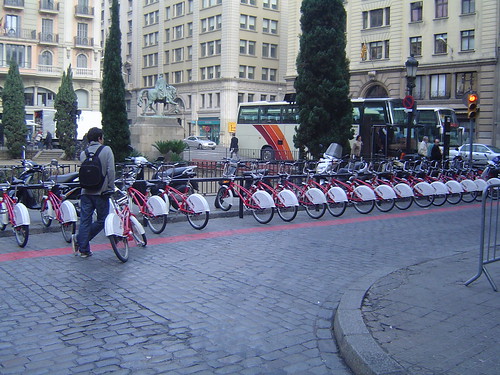
Daily urban difficulty, waiting for a free and working slot at a Bicing station in Barcelona.
Why do I blog this: As always enjoying Adam’s pragmatic view on the state of urban informatics that echoes well with Sliding Friction, From Sentient to Responsive Cities, Embracing the Real World’s Messiness and Phil Hubbard’s hybrid city. I would add to Adam’s comment that urban informatics also add new types of frustrations. In addition, our ability to overcome the tiny urban frustrations and difficulties is part of the joy of urban life. I would argue that urban informatics are about promoting this sustainable chaos and not eliminate it (Visions of “Next Generation” Cities).
Posted: August 5th, 2008 | No Comments »
Potential venues to submit this Summer’s research outcomes:
AAAI Spring Symposium 2009 – Human Behavior Modeling
This workshop will explore methods for creating models of individual and group behavior from data. Models include generative and discriminative statistical models, relational models, and social network models. Data includes low-level sensor data (GPS, RFID, accelerometers, physiological measures, etc.), video, speech, and text. Behaviors include high-level descriptions of purposeful and meaningful activity or abstractions of cognitive and affective states. These include activities of daily living (e.g., preparing a meal), interaction between small sets of individuals (e.g., having a conversation), mass behavior of groups (e.g. the flow of traffic in a city) and related internal user states.
Deadline: October 3, 2008
4th International Symposium on Location and Context Awareness
technical papers describing research results on systems, services, and applications to detect, interpret and use location and other contextual information. Context includes physiological, environmental and computational data whether sensed or inferred. In addition, context includes users’ activities, goals, abilities, preferences, interruptibility, affordances, and surroundings. With context, we can expect computers to deliver information, services, and entertainment in a way that maximizes convenience and minimizes intrusion. Developing awareness involves research in sensing, systems, machine learning, human computer interaction, and design.
Deadline: December 18, 2008
See previous list of CFP Special Issues, Workshops and Conferences
Posted: August 5th, 2008 | No Comments »
In his PhD thesis Understanding Cyberspace Cartographies: A Critical Analysis of Internet Infrastructure Mapping, Martin Dodge describes the different approaches in cyberspace cartographies to reveal what the Internet looks like. His work takes an interpretive stand with a focus on the connotative meaning and power of statistical mapping to represent the nature of the globalisation of Internet connectivity. Then, on a more critical stand, Martin provides insights into how different interest groups want the Internet to look.
Relation to my thesis: Part of my work is to map the data generated by our interaction with the multiple Internet infrastructures to “reveal the invisible”. That is maps OF cyberspace from cyberspace census-taking as exemplified by Jean Gottman‘s statistical map of telephone calling patterns from Washington DC (p. 79) to reveal a megapolis. But then it is still unclear what is the nature of power these new types of maps mirroring our own activities have to do work in the world.
Posted: July 29th, 2008 | No Comments »
These past week, a couple of my follow-up works on the preliminary Tracing the Visitor’s Eye case study based on Florence have been accepted. I will be presenting the position paper “Assessing pervasive user-generated content to describe tourist dynamics” at the First International Workshop on Trends in Pervasive and Ubiquitous Geotechnology and Geoinformation on the need and methods to understand the users practices behind the generation of digital footprints and their relation to the urban space. In addition, the paper “Digital footprinting: uncovering the presence and movements of tourists from user-generated content” will be published in the IEEE Pervasive Computing Magazine, special issue on Pervasive User-Generated Content. It showcases the ability to uncover the presence and movements of tourists from geo-referenced photos they explicitly make public, as well as from network data implicitly generated by users of mobile phones.
Besides encouraging reviews on an “exciting area of research with lots of potential” some comments suggest some areas I should focus my current and future data analysis on:
Reveal the unexpected
- “it would be interesting to hear whether any of the findings were unusual/unexpected”
- “delve deeper into how “digital footprints” provide novel observations/results compared with traditional knowledge (expend to other nationalities)”
- “also focus on people taking photos in their own city (how are they different?)”
In consequence, I am exploring methods to reveal abnormal behaviors from time series, and to profile users from their use of the system and their mobility.
Space and user profiling
- “other automatic group categorization are possible (type of camera?), segmentation of the cellphone data as well”
- “what areas are more prone to be taken with a camera phone than a digital camera? and how does this evolves?”
- “hypothesis: tagged data is likely to be of fairly high quality (accurate and semantically meaningful)”
- “different types of tourists may geocode photos differently (American tourists are much less adept at geocoding location apart from thos most famous landmarks than Italian tourists”
Validation
- “conclusions are conjectures and not yet validated (they are obvious and not too controversial)”
- “methods of validation will likely have to be developed”
- “how to assess the impact of the biases in the data?”
- “in what ways does the passively collected data accurately reflect reality?”
- “additional investigation into the reasons for the discrepancies between datasets seems warranted. Do the demographics of photographers match the demotraphics of the mobile phone users? This additional analysis may help more convincingly explain the validation discrepencies and provide an avenue for correcting biases.”
In consequence, I am collecting hard data from traditional surveys that should represent the reality to compare to and calibrate to if they correlate.
Heterogeneity of the analysis
- “tie more together explicitly each analysis (presence and flow)”
- “are there other types of analysis (besides presence, flow, semantics)”
In consequence, I have to set an exhaustive list of what can be analyzed for each type of digital footprint and digital shadow. Then explain the scope of each type of analysis and how they relate to each other.
In consequence, I have extended the features that characterize users (e.g. type of camera, taken time and upload time difference, categories of tags used, …) in a correlation matrix. Use of proximity function and clustering techniques to define groups of users. Use of Characterization techniques as seen previously in Methods to Study Flickr Users Behaviors.
Posted: July 28th, 2008 | No Comments »
The interdisciplinary project Visualizing Cultural Patterns (see also Visualizing Cultural Patterns and video) was created on the novel opportunities to studying social and cultural processes from large amounts of data about people’s cultural behavior and preferences as well as cultural assets themselves in digital form. In the same vein as Bruno Latour’s essay on digital footprints (and other sources), this project starts from the observation that:
The joint availability of (a) large cultural data sets (through the Web and digitization efforts by museums and libraries) and (b) tools already employed in the sciences to analyze big data makes feasible a new methodology for the study of cultural processes and artifacts. If humanities have typically relied on the manual analysis of a small number of cultural objects, we can now create information visualizations of large cultural data sets to discover patterns that have not been visible previously.
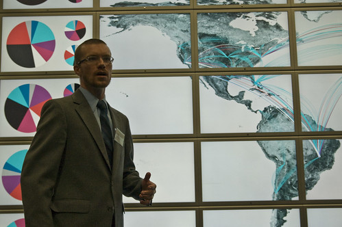
Lev Manovich present interface design for Cultural Analytics Research Environment running on HiperWall. Photo courtesy of Anne Helmond
Relation to my thesis: A growing number of researchers start take advantage of digital footprints . This one proposes an interdisciplinary approach with a combination of expertise in Visual Arts, Communication, Cognitive Science, and Structural Engineering. I am really intrigued by their use of computer-based analysis and visualization of large data sets and data flows used that should go beyond eye-candy mashups.
Posted: July 28th, 2008 | No Comments »
Autodesk officially launched their Digital Cities initiative with a first pilot in Salzburg. Their approach relies on a shared 3D collaboration and visualization environment for data from architectural models, utility networks, transportation networks. The aim is to foster a holistic approach to city management from engineering-level models to visualize, analyze, and simulate the real world. In an interview on the initiative, Doug Eberhard, Autodesk’s senior director for digital cities highlights the importance of this approach to communicate early in project:
The current process has been called the DAD method (decide, announce, defend), but that’s changing. By communicating early and often, you eliminate a lot of backlash. Digital cities allow you to share projects with the public in a robust and meaningful way.
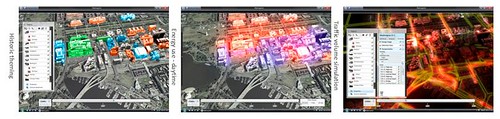
Snapshots of the Digital Cities Metropolis demos
Update: Doug Eberhard “Digital Cities” presentation at Where 2.0.
Relation to my thesis: A corporate vision on the management of hybrid cities (see also Arup’s Future of Connected and Sustainable Cities). I wonder if the move from 2D to 3D and 4D provides better perspectives to collaborate and take decisions. From my experience, novel urban visualization based on more social data than the ones handled by Autodesk have a real added-value for local authorities to communicate and reveal some invisible aspect of a city (such as in Florence). However, the fluctuating quality in the data often still not taken into consideration in the visualization often prevent from decisions to be taken. Bad or missing data also come from the current unsustainable digital practices in cities. I have noticed several time that agencies don’t share information or we share it in unsustainable ways.