Posted: December 23rd, 2007 | No Comments »
A few events I would love to attend in early 2008, but I unfortunately won’t be able to…
The Mobile City conference
Is it still useful or even possible to talk about the city as being only physical? Or about the digital world as purely ‘virtual’ (in the sense of ‘not real’ oimmaterial)? The physical city and the spaces of digital technologies merge into a new “hybrid space”. Hybrid spaces are shaped by the social processes that concurrently take place in digital and physical spaces. What is the influence of these developments on the ideas we have of time, space and place, citizenship and identity?
4th and 5th seminars in the ESRC Research Seminar Series: Rethinking the Urban Experience: the Sensory Production of Place
Seminar on the sensory awareness of urban infrastructure. This seminar will ask questions about the infrastructure that supports urban society. Topics may include sensory experiences of public transport networks, olfactory responses to waste and its disposal, public toilet provision in urban areas. Additionally, the role of hidden infrastructures such as CCTV and underground infrastructures such as utilities networks will be considered in this seminar.
EPFL Choros group “Penser l’espace” seminar with a focus on the “critique de la raison cartographique” and the multiple perspectives to think about space.
Quelles habitudes de pensée sont charriées lorsqu’on cartographie ? Quelles sont les implications de la réduction cartographique de la complexité de l’espace ? De quelle façon peut-on contrôler le passage des données à la carte ou le passage de la pensée à la carte ? Comment cartographier de l’espace contemporain – ce « space of flows » et hyperurbanisé – où la mobilité et la digitalité sont les caractéristiques fondamentales ? Quelles sont les implications du passage de la carte sur papier à la carte sur écran ? Le GPS et Google Earth transforment-ils notre rapport à la carte, et, partant, notre rapport à l’espace ?
Pervasive Persuasive Technology and Environmental Sustainability workshop at Pervasive 2008
The key theme of this workshop around environmental sustainability will be addressed threefold: 1. Providing people with environmental data and educational information, 2. Pervasiveness can easily turn invasive. It has already caused negative consequences in biological settings. 3. digital divide between humans and the environment (e.g. Can the process of ‘blogging sensor data’ (sensorbase.org) assist us in becoming more aware of the needs of nature? How can we avoid the downsides?
Inaugural Research Institute for the Science of Socio-Technical Systems
A science of socio-technical systems is emerging from research in the fields of HCI, social computing, social informatics, CSCW, sociology of computing, and other domains. The Consortium for the Science of Socio-Technical Systems (CSST) is a new organization devoted to advancing research on socio-technical systems. A primary goal of the institute is to build a new cohort of faculty and graduate students who are interested in research on the design and interplay of technology and humans at the level of individuals, groups, organizations, and larger communities.
ifgi Spring School 2008
Two weeks of short block courses with innovative topics in GI such as: geospatio-temporal information: issues in representation and reasoning, usability and user-centred systems, location-aware systems, information visualization & presentation, and research methods
Posted: December 18th, 2007 | 5 Comments »
After 2 years in the relaxingly dynamic Barcelona, I am now moving to the climaticaly-challenged US East Coast. I will spend 2008 as a visiting scholar at the MIT SENSEable City Lab in Boston. Looking back in my plans when I started my PhD, it seems that have reached many milestones and I keep on a good track. I defended (with success) a DEA thesis, contributed and participated to some of the major conferences in my research field including Ubicomp (’06, ’07), Pervasive, CHI, LBS, got some words out on my work in publications IEEE Pervasive Computing, e-minds, space time and play in non-academic events such as Lift, Picnic, Mobile Monday and Immotic-Domotic. Time now has come to cut a bit on the talking and focus more on the thinking/doing in the studies I lead co-evolution of taxi drivers and their satellite navigation systems, tracing the visitor’s eye and projects I (will) contribute to like WikiCity and the Wireless City. Instead of attending conference (only Lift and the AAG meeting are on my schedule), I plan to thrive on lab visits and face-to-face discussions.
My move to the MIT Department of Urban Studies and Planning indicates a wish to enrich my professional profile with theoretical knowledge in city design and development. Quoting the IEEE Pervasive Computing issue on Urban Computing: “Urban settings frame social behaviors. They encompass architectural forms and features that might not be harmonious with given technologies, and they’re variably permeated by wireless networks and fixed and mobile devices” it is clear that the urban space will need researchers with mixed competences in engineering, HCI (call it user experience or interaction design) and urban planning. The recent Urban Computing and its Discontents by Adam Greenfield and Mark Shepard comforts me in that vision.
Relation to my thesis: the major challenge of 2008 will be to make my different studies and projects fit into a coherent PhD thesis.
Posted: December 15th, 2007 | No Comments »
I have been on the field collecting more observations and interviews on the adoption of GPS by taxi drivers in Barcelona. On one hand I am interested in the co-evolution process and the modifications of the practices, on the other hand I focus on the context of use of the technology (other artifacts/tools, influence of landmarks, type of location information used (how, where, when, granularity). Here are a few notes that will need to be interpreted further. I collected data from a unbalance population of either find very experienced (15+ years: seniors) taxi drivers or novice in the practice (2- years: juniors). It has been harder to anybody in between. At least, it revealed dissimulates in the appropriation of the technology between the “seniors” and “juniors”.
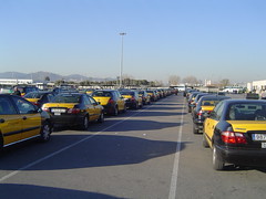
Uniformity in the wild
First of all, there is a concenus that GPS an unbeatable tool when it come to reaching a specific destination in a village and leaving it (link to previous post). It is a strong reason to acquire a sat-nav system. But it is not really to be more productive and hence earn more, rather than feeling more serene (i.e. tranquility was the word). Some mention that it does not only tranquilize them but also their clients (“they know I cannot cheat them with it”, “it reassures them that I go to the proper destination”). When it comes to seniors, they now know that they have a “companion” (some refereed to their car with an affectionate “she” and their sat-nav with a “he”) can take them anywhere and avoid these moment when they had to search endlessly browsing the street directories of the suburbs of Barcelona, asking their colleagues via radio or mobile phone. One mentioned me that “the fear of getting lost with a client I felt in my stomach now disappeared”. Another was relieved that he did not have to use his radio to ask colleagues about particular location informations and wayfinding (even though many taxi drivers are extreme social animals). Currently the radio is uniquely used to get dispatching orders and professional questions (e.g. asking on special rates for some destinations). To get out of the unfamiliar environment, the driver would be either very cautious in the path taken to enter the area (“I am a very good observer”) or use their GPS with destination Barcelona. In their exit strategy, their reach their bookmark of saved destinations are hit “home”, “Barcelona, any street”, or “Barcelona center”.
Disparities in the urban space
However, when it comes to the context of the city, practices differ and the “Guia” comes into play. The “Guia” is a dense book of all the streets and POI in Barcelona. Experienced drivers have been using it all their professional lives and have partially learned the city with it. Another big part of the knowledge drivers acquire come from the clients themselves. They know all the tricks and secrets official books and commercial systems can’t tell. As the experience drivers contain most of the knowledge of the city in memory they rarely return to the Guia. In fact, they prefer using their sat-nav and hit the Guia only as fail-over (e.g. when the system does not contain a street number or lacks of information). Even after 20 years of experience, one drivers still perceived accessing the Guia as a demanding task. Compare to that, hitting the screen of his Tom-Tom was a pure pleasure. This process of accessing correct information is executed differently by the juniors I interviewed. First, they had mixed feelings about their experience with their GPS (“It is like my mobile phone, sometimes it does not work well”, “it is a potential problem”) in terms of quality of services and precision of the information. They very early reached the limits of the systems and the inaccuracy (erroneous information) of the system directly impacted the quality of their service (mostly because they had to deeply rely on it in the beginning). In consequence, they embraced the use of the “Guia” which is “more accurate and complete” (particularly when it comes to POI). In the city, they learned not to completely rely on their sat-nav (because it is hard for them to judge if the information is erroneous or not) and first open the “Guia” prior to enter an address. One told me that he learned to interpret the system and its errors. When a conflict emerges between his sat-nav and his “knowledge” he starts to “improvise” (in his own terms). Depending on the circumstances he would either switch it off or ignore it for a while.
The confirmation of the funnel
Confirming what I mentioned previously, the wayfinding practice takes place in 2 main stages. There is a separation difference between “ir” (to go) and “llegar” (to arrive) and the location information are different in each phase. First the driver has the knowledge of the area where to go or checks in the Guia to get a rough awareness of destination (one driver told me he would directly enter the address in his navigation system). This is done at any occasion at a traffic light or in dense traffic (if the driver knows he will have to go on the highway directly, he/she will check prior to leaving). It is only at the entrance of the area (e.g. a neighborood – it would be interesting to define it better) that the active mode of the sat-nav system starts by entering the full address (once again taking advantages of traffic lights and busy traffic).
Mobile phone
The mobile phone often available is seen as a social link to family and friends, and is very rarely used as a tool to support their work. One driver told me that he used it a few times to check if a table was available at a restaurant for clients (particularly foreigners). This is a service he gives as added value, but he “normally should not do it”.
Passive mode
As mentioned in a paper by Nick Forbes,there is a clear tendency to keep the system in passive mode at any time. It is done so mainly to keep track of the radars (seems to be more a priority for experienced drivers) and (for juniors) to keep an awareness of where they are (keep track of the proximate streets) and it was also very valuable to learn the city. On this point, an experienced driver explained me that younger drivers who use a navigation system do not gain knowledge of the city, because they follow the recommendations and “stop to think”. My contact with the younger generation proved somehow the opposite. They are eager to learn the city and the imperfection of their systems forced them to get knowledge from the “Guia” and from the clients.
Relation to my thesis: Working on The co-evolution of taxi drivers and their in-car navigation systems, I stereotyped a bit the practices based on my notes to reveal the main patterns. I keep 3 main tracks that are worth investigate more in details:
- different appropriation of the location-aware system depending on the overall knowledge and experience of the space. The shortcoming of GPS forced the younger generation to rely on the Guia, while the older generation has little use of the Guia now. This goes in the direction of understanding and supporting “mobilities” instead of mobility.
- a tool not to make more money, nor to improve the efficacy, but to tranquilize (“I can go everywhere”) and relax (e.g. passive mode to have a continuous awareness)
- funnel-type of access to location information (I will model the process, this is part of the understanding of granularity) with multiple sources (kwnoledge, sat-nav and Guia)
Posted: December 9th, 2007 | No Comments »
Last Friday, at the Salon ImmoTICs DomoTICs Agora in Sophia Antipolis, France, I was very fortunate to present some of my work in a slot between the french “paleanthropologist” Pascal Picq and the italian architect David Fisher and later the economist/thinker Michel Godet. My talk (in french) entitled “Révéler le pouls de la ville” was a duplicate of what I presented at Mobile Monday Barcelona, with a stronger emphasis on the implications of the use of “digital footprints” by urban planners, local authorities and designer of urban digital infrastructures such as location-based services. The slide are available online: Révéler le pouls de la ville.
Thanks to Dominique Thibault for the kind invitation.

Relation to my thesis: testing my ideas + practicing public speaking (it is definitively either in my mother tongue) + getting in touch with french academics who do not always communicate outside of the boundaries of the “hexagone”.
Posted: December 4th, 2007 | No Comments »
Last night, I participated to the Mobile Monday Barcelona event on Location-Based Services. My talk entitled “Mapping of City Dynamics” covered some innovative ways to use mobile and wireless technologies to sense the city and reveal its pulse (i.e. its activity in space and time). I also discussed their underlying concepts (real-time, history, feedback loop, implicit and explicit acts, experience of the city, consequences of our activities) and their implications in relation to the design of location-based services that raise. Finally, I exemplified these ideas by introducing the ongoing project lead at the SENSEable City lab, named WikiCity, that aims at offering an instrument for city inhabitants to base their actions and decisions upon in a better informed manner.
Thanks to Rudy and Carles for the invitation! (Flickr set of the event)
The slides with my notes are available: Mapping of city dynamics

Relation to my thesis: Pushing the ideas on urban computing and the design of LBS (granularity, areas of influence/relevance, uncertainty) and getting good contacts to understand the partitioners perspectives. and past experiences. I will do a similar talk on Friday at the ImmoTICs DomoTICs Agora event in Sophia Antipolis.
Posted: November 19th, 2007 | 1 Comment »
Humans think and talk about regions imprecisely in terms of vague concepts (e.g. downtown). While administrative regions such as area codes and land parcels have sharp boundaries imposed on them, other regions concepts used by people are more fuzzy. The use of vague spatial concepts in geospatial communication have been studies for many years (see for instance Daniel Montello’s Where’s downtown?: Behavioral methods for determining referents of vague spatial queries). However, the understanding human’s perspective of the space hardly translates to its digital definition stored geographic information systems. As a consequence, the local search and location-based services industry has invested a large amount of energy and money in obtaining neighborood expertise. Companies such as Urban Mapping sells its extensive user-centered neighborhood datasets to major search engines. New approaches profit from people submitting their own version of the boundaries for the same neighborhood. WikiMapia is an example of this kind of community editing. It defines specific areas (roads, parks) with polygonal entries (see Matt Jones’ Wikimapia Invades Google Earth!. Similarly, the Intelligent Middleware project at the MIT aims at providing a mechanism for accumulating local knowledge about neighborhood-scale land use. This people-generated content helps re-interpreting the administrative datasets and develop customized analyses of neighborhood conditions.


A classic Neighborhood areas & census block groups (2000) by the Seattle City Clerk’s Office neighborhood map atlas (right). People-defined neighborhoods and areas of Barcelona in Wikimapia
Nowadays, there are new sources to implicitly reveal the crowd “mental maps”. This has mainly been done by via tag maps such as the ones generated by WorldExplorer. In Tracing the Visitor’s Eye, I am currently taking this idea a bit further and try to generate the “area of influence” of monuments and points of interest. This work should reveal a spatial relevance of geographic objects as zones (i.e. neighborhoods) instead of administratively-defined points or rectangles (like the ones provided by GeoNames). Inspired by Jonathan Raper’s concept of “Geographic relevance” (match between area of attention and area of influence). For instance, areas defined implicitly by people’s behaviors (mobility, digital traces) and activities (geotagging) could help provide more relevant answers to queries based on monuments and proximity such as “what is close to the Empire State Building?”

A crowd’s mental maps of Barcelona in WorldExplorer
Update: I forgot about the The Neighborhood Project (mentioned previously), as an attempt to map what street addresses people on Craigslist consider to be within certain neighborhoods. One problem with, though, it is that Craigslist provides a certain list of neighborhood names and they aren’t necessarily the same ones that people use in real life.

Neighborhoods defined by people using Craigslist.

Jonathan Raper’s Geographic Relevance presented at LBS2007
Relation to my thesis: Exploring the relationship between people’s perception of neighborhood and the concept of location information granularity.
Posted: November 17th, 2007 | No Comments »
On the kind invitation of Juan Dürsteler, I contributed to the InfoVis.net newsletter with a text on current approaches to visualize urban activities and their evolution through space and time: “Visualising the Pulse of the City” and in Spanish “Visualizando el Pulso de la Ciudad“.

Posted: November 17th, 2007 | 3 Comments »
After 2 years of doctoral school and the defense of my DEA thesis (pdf), I guess I now hold a Master of Philosophy in Computer Science and Digital Communication. The slides of the defense are available here.

Relation to my thesis: The defense ended up being a bureaucratic formality. One feeling I have after having presented the same slides a few times this year is that I now drag and try to combine too many concepts together. To move forward, I will need to make choices and trim my scope and get more depth in the details.
Posted: November 11th, 2007 | No Comments »
In April of next year, I will attend in Boston the AAG meeting and participate to a session on “Situating Sat Nav: Questioning the TomTom Effect“. Organized by Chris Perkins and Martin Dodge, it aims to address the social effects, cultural meanings and political economy of in-car satellite navigation. I will be in the middle of a spectacular line-up:
Session One
Amy Propen: The Use of Sat Nav Systems: An Empowering Cultural Practice or Portentous of a Lost Geographical Imagination?
Don Cooke: The TomTom Effect: Industry Point of View
Allan Brimicombe and Chao Li: Sat Nav: Rising theft of a geo-engineered must-have.
Tristan Thielmann: Navigation becomes travel scouting: The augmented space of car navigation systems
Caren Kaplan: Precision Targets: Consumer Subjects, Militarization, and the Politics of Location.
Session Two
Fabien Girardin: The co-evolution of taxi drivers and their in-car navigation systems
Georg Gartner: Restrictions in mental representations of the world as a result of relying upon navigation systems
Jonathan Raper: The mistakes that satnavs make (and what they don’t know)
Alexander Klippel: Can we afford to provide cognitively inadequate wayfinding assistance?
Discussant: David M Mark
The abstract of my paper entitled “The co-evolution of taxi drivers and their in-car navigation systems” goes as follow:
In the recent years, the massive use of in-car navigation systems has symbolized the emergence of location-based services for wayfinding. This market success creates the opportunity to learn from a real-world use of present location-aware systems in order to inform the design of future applications. In that context, we are using an ethnomethodological approach to study the different ways taxi drivers rely on their navigation system. First, this work focuses on describing how location technologies impacted the wayfinding practices and similarly how the practice influences the appropriation of navigation systems. This co-evolution starts from the acquisition and setup of a navigation system to mastering the system shortcomings and limitations. Second, we study the criteria that steer a driver in selecting among the different modes of a navigation system and the other artifacts and tools (e.g. maps, street directories, landmarks) he or she uses for location awareness and wayfinding. Moreover, we are analyzing the role of context in this dynamic. That is where and when a driver accesses location information from the system, the external supports and the surrounding environment. We are currently collecting data from 20 semi-structured interviews each augmented by in-car observations of 1-hour ride. The study concentrates on the taxi drivers of the city of Barcelona, Spain. This community forms a massive population of early adopters of in-car navigation systems with a strong past practice of relying on mobile technologies and maps to support their work.
Relation to my thesis: I can’t imagine a better set of people to receive feedback on my taxi driver study.
Posted: November 9th, 2007 | No Comments »
I am in Hong-Kong for the 4th International Symposium on LBS and TeleCartography where I introduced two different works in the Mobile Users Analysis track. First I presented my paper “Understanding of Tourist Dynamics from Explicitly Disclosed Location Information” that describes the early results of the Tracing the Visitor’s Eye project based with data collected in the Province of Florence. I intended to communicate the complementary perspective new types of digital footprints can bring to mobility, urban and travel studies. The content of other presentations in the session (mainly Ahas Rein‘s Mobile Positioning: New Perspective in GIS and Geographical Studies. Ahas chairs an upcoming workshop on social positioning method) that are based GSM network data, helped situate the originality of my approach based on act of communications “I was here” instead of passive, implicit mobility data. It means also no issues of scalability, infrastructure and negotiations with operators. I suggested the idea the explicitly disclosed location data can help inform the design of LBS (e.g. help define area of attention of people, the area of influence of objects, and the granularity of information). Finally, of course, I mentioned the feedback loop generated by people’s past interactions with the urban environment and infrastructure that become recommendations and impact the perception of the space.

Understanding of Tourist Dynamics from Explicitly Disclosed Location Information (slides in PDF)
Later, I presented (on behalf of the WikiCity team) the main concepts and design of the MIT SENSEable City Lab current project WikiCity. Without getting into the technical details, I stressed the importance of developing a real-time mapping of city dynamics for people to become actuators and prime actors of the cityspace. The scenarios of WikiCity is based on the fusion of 3 elements agents (individuals, companies, local authorities…), the environment (architecture, infrastructure, climate…) and technology features (opportunities and limitation positioning and sensing technologies. A main challenge is to provide a common format for interchange of realtime location-based data and to communicate the information to multi-modal interfaces (close to the person such as mobile/fixed devices, embedded in the infrastructure, vehicles (public transport, individual cars).

WikiCity: How can a city perform as an open-source real-time system (slides in PDF)

