Posted: November 4th, 2007 | No Comments »
An upcoming issue of Built Environment will feature combine insights from social and technical disciplines to highlight opportunities of how mobility systems can be shaped so that they are not only technically efficient but also socially accepted and used. As suggested by its title “Sustainable Socio-Technical Mobility Systems” the approach of urban sustainability does not solely tackle technical nor an exclusively social problem, but rather a co-evolutionary dynamics in urban socio-technical ensembles. For example, employees working in a building with no shower are understandably reluctant to cycle to work. In short, the built environment and social mobility practices are inherently intertwined and constitute a system of mutually shaping parts.
The issue is edited by Ralf G. Brand, the author of Synchronizing Science and Technology with Human Behaviour in 2005.
The CFP goes as follow:
Many scholars, in particular those in the field of Science and Technology Studies (STS), argue for interdisciplinary collaboration to develop not only a better grasp of socio-technical systems but also to devise more effective policy advise on how to make such systems more sustainable. However, it has not yet become standard practice for STS scholars to expose themselves to the engineering details of, say, more sustainable mobility systems.
Conversely, it seems fair to state that engineers typically do not systematically seek advice from social scientists – or only in an “end-of-pipe” fashion to advertise resource efficient products to public, corporate or private consumers. The Fourth Dubrovnik Conference on Sustainable Development of Energy, Water and Environment Systems is trying to provide a venue where a more truly interdisciplinary dialogue about sustainable development – in particular about sustainable transport – can take place.
Its conceptual starting point is the acknowledgement of sustainable development as a complex, multi-criteria challenge requiring interdisciplinary collaboration. Papers exploring “engineering, social, and environment aspects” of sustainable transport are therefore invited as contributions to the emerging field of sustainability science. The special session on a socio-technical understanding of transport systems will be a platform for such cross-fertilisation and mutual refreshment. Its contributions will offer insights from recent STS research about the hybrid constitution of sustainable transport systems and the systemic interweavement of their social and technical elements. Papers are also invited about concrete tools to put these insights to action, like Co-evolution audit, Strategic Niche Management (SNM), Constructive Technology Assessment (CTA), Co-Evolutionary Sociotechnical Scenario Method (CEST-method).
Relation to my thesis: The co-evolution mentioned in this issue focuses on the mutual shaping processes between all kinds of urban artefacts (road networks, buildings, street furniture, etc.) and social practices (shopping routines, perceptions of safety, commuting patterns, etc.). Now, new urban technologies (GPS, wireless networks, Near-field communication) also support mobility systems and impact the social practices and vice-versa. The analysis of this process should certainly inspire from previous work in urbanism and sustainable architecture. Finally, I particularly enjoy that the editor calls for the analysis of both failed and successful projects conducted under the flag of sustainability. It is particularly rare in research to considure failure as an outcome as already mentioned by Nicolas in Dark data to be set free.
Posted: November 3rd, 2007 | No Comments »
In his presentation at Open Plan in 2005, Bill Gaver implicitly mentioned a few concepts I am currently focused on. First he presented the The Urban Pollution Monitoring Project that provides some sort of feedback loop to residents in providing resources to reason themselves about fluctuating pollution in the city space. The system providing information about the content, but also about the infrastructure providing the content (i.e. a sort of seamful design). Then he highlighted the notion of “over time” with a project by Richard’s Swinford‘s use of GPS traces and their use of satellites to carve out the boundaries of the physical space. It shows that the model of the phisical world can be created in a bottom-up fashion (implicit digital traces) and reflect reflect “over time” of individual’s knowledge on the local space. In other words, there is a connection between the system produced and the places they inhabit that grows and can can be appreciated over time for instance in a game or to support social navigation. The data of this spatio-temporal use come from the technologies themselves or the experience of the people using them. OpenStreetMap (evolution in London and Great Britain), courier activity and cabspotting are clear examples of the former.

Realising the extensions of man by llistening to the user: model the neighborhood in 3D by using GPS and the satelites. The model gains in accuracy with the use of the system. Source: Richard’s Swinford. I guess it uses the same kind of data at the Anthony Steed’s GPS Availability Visualization.
Later in his talk, Bill mentioned Ben Hooker and Shona Kitchen project called Edge Town done in 2004 that aimed designing interfaces with the flows of electronic data that run through our cities so that “they can be experienced as an enriching complement to other, more ‘earthly’ phenomena”. I was fascinated by then (and still am) by their Sensor park aimed to be situated in tumultuous landscapes, such as directly underneath the airport’s final approach flight paths. The structure of the sensor park provides support for a host of screen-based and electromechanical displays, which offer numerical representations of the data collected from the sensors. This type of information would be provided to Edge Town resident and experienced for their week-end recreation.


Sensor park in the Edge Town project
Relation to my thesis: Tagging with concept names a 2-years old message… I got to know Bill Gaver from his Ambiguity as Resource for Design.
Posted: October 30th, 2007 | No Comments »
Today I gave a talk to my research group on the current state of my investigation. The presentation covered the topic of my DEA work, the early results of Tracing the visitor’s eye project and their implication for a field experiment taking advantage of digital footprints to support social navigation and seamful design. One personal goal of this presentation was to prepare my DEA defense in November and next week’s presentation of Understanding of tourist dynamics from explicitly disclosed location information at the 4th International Symposium on LBS & TeleCartography.

Towards Reducing the Social-Technical Gap in Location-Aware Computing (PDF)
Relation to my thesis: Trying to put the pieces of the puzzle together. The overall argumentation still lacks of coherence. I will need to make some choices and get rid of some themes to explore others profoundly. Most of all, my research questions are now outdated. I need to refine them. More on that later.
Posted: October 30th, 2007 | No Comments »
A book in the making, Urban Informatics: Community Integration and Implementation will include contributions from (among many others) Anthony Townsend, Carlo Ratti, Adam Greenfield, Paul Dourish, Genevieve Bell, Vassilis Kostakos, Christian Nold, Eric Paulos. Some of the contributions come from the presentations given at the Digital Cities 5 workshop at the 3rd International Conference on Communities and Technologies 2007. It is edited by Marcus Foth.
Foth, M. (Ed.) (2008, forthcoming). Urban Informatics: Community Integration and Implementation. Hershey, PA: Information Science Reference, IGI Global. Contracted 28 Jan 2007.
Posted: October 22nd, 2007 | 1 Comment »
Relation to my thesis: The ubicomp of the present: situation provoked by the presence and absence of the “cloud of connectivity”.
Posted: October 16th, 2007 | No Comments »
Over the weekend, I collected minute-by-minute data of the usage of Bicing (community bicycle program in Barcelona) bikes. The animation of these spatio-temporal data slightly reveals the dynamics of “cyclists” hanging out at the beach on Sunday afternoon (left) and then returning downtown in the evening (right).
View video animation
Relation to my thesis: This little hack joins two of my current train of thoughts. The first on the complexity of deploying of urban (computing) infrastructures (Bicing is an excellent case study) and on the second: taking advantage of the digital traces left by people interacting with technologies to reveal and act upon the imperfections of the systems.
Posted: October 8th, 2007 | No Comments »
Andy Hudson-Smith Senior Research Fellow at the Centre for Advanced Spatial Analysis (CASA) published a new working paper out entitled ‘Digital Urban – The Visual City‘ in which he depicts the recent revolution in the production and distribution of digital artifacts which represent the visual city. Indeed, In the decrease in knowledge required to create and present geographical information is leading to a direct increase in the amount of information available. The emergence of georeferenced user-generarated data streams can by built into one Visual City with a personal flavor (i.e. Personal City):
In essence, we are but at the beginning of what will be a revolution in social, visual and informational data plotted geographically by general users. The rise of social networks provides us with the ability to look down on the city and view the activities that its citizens are involved in. This ability provides unique social data and an insight into how the citizens are thinking, working, and socialising.
Relation to my thesis: follow-up on Representing Spatio-Temporal Traces. What I find compelling about the emergence of the “personal city” is that the data do not come from the explicit annotation of the space, but rather from the residues of activities involving space (e.g. categorizing or sharing photos, communicating with a “subtle” location-awareness (twitter with a location attribute).
Posted: October 7th, 2007 | 1 Comment »
So Nicolas opened a pandora box by mentioning in Chronotopic visualizations: representing traces of people in spatial environments that the collection and representation of traces left by people in space through technologies is gaining momentum in location-based computing. In the past, this type of research aimed at understanding mobility and travel behaviors or predicting them (e.g. John Krumm’s work on “Predestination”). However, the collection of mobility data is time consuming and requests non-negligible efforts in setting-up and deploying surveys infrastructures. The costs and privacy issues prevented such studies to move beyond the scope of transportation research (see Jean Wolf’s Applications of New Technologies in Travel Surveys for a survey). Now, the accessibility to affordable wireless sensors and the emergence of the geospatial web are generating new types of “digital footprints” left by people in space though technologies. My Tracing the Visitor’s Eye project is one example among many. For instance, Danyel Fisher developed Hotmap to visualize where in the world people look at when they use Windows Live Maps (see Imaging the City workshop and Fisher’s Hotmap looking at Geographic Attention.

Density of people “querying” Boston through Windows Live Maps. Courtesy of Danyel Fisher. Made with Hotmap
Now, as Nicolas questions, What types of affordances these new types of data/visualization create? First, they might be directed at professionals such as urban planners to build or refine their models, but also to any kind of industry that deploy services or infrastructures supporting mobility throughout a city. For instance, it might inform on the installation of Municipal Wi-Fi. A second line of investigation aims at feedback information back to the people in order to creating a control or feedback loop (i.e. a “mirror to ourselves”). This approach makes use of social navigation (”navigation towards a cluster of people or navigation because other people have looked at something“) to help individuals make more informed decisions about their environment. A few weeks ago in Rome, the MIT SENSEable City Lab closed the feedback loop as a first example of their Wikicity project. They aggregated various types data and visually mapped the density and movement of people, buses, taxis in real time throughout the whole of the Eternal City. “By revealing the pulse of the city, the project aimed to show how technology can provide the inhabitants with a better idea of their own city and can help adjust their behavior accordingly. In the context of the web, Mor Naaman translates the feedback loop into a “social media cycle” (see the slides of his presentation this week at Yahoo! Research Barcelona: How Flickr Helps us Make Sense of the World).

Crowds gathered outside Rome’s Museum of the High Middle Ages on September 8, 2007, to view a real-time display of population movement during the city’s Notte Bianca festival. (Courtesy of MIT’s SENSEable City Laboratory). In the media: ‘Wiki City Rome’ to draw a map like no other, City life on the screen, Wikis, the Semantic Web head to the streets, Les cartographes du téléphone mobile
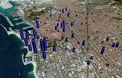
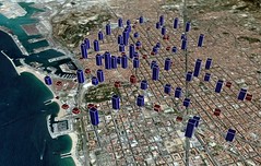
Last week at Picnic, Adam Greenfield gave a presentation “The City is Here for You to Use: Urban Form and Experience in the Age of Ambient Informatics” in which he discussed how everyware is already affecting cities. More specifically, he mentioned this new types of real-time information about cities and their pattern of use, visualized in new ways and that information can be made available locally on demand in a way that people can act upon.
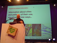
Adam Greenfield at Picnic07 on visualizing the patterns of use of the city: Stamen Design’s cabspotting, crime and real estate mapping, map of cities with WiFi hotspot.
Current scenarios for the application of these real-time visualizations mainly aim at facilitating a quick search or decision making such as determining a jogging path that corresponds to a combined query, or pedestrians that may eventually turn to interactive maps to avoid the masses or catch a bus. Other scenarios that take advantage of the temporal and social aspects of the traces could emerge. Such as providing an interactive tourist map of Switzerland based on Flickr traces revealing Zermatt, Interlakend and Davos and obscuring the non-relevant geographical location. But then, what are the scenarios beyond that?
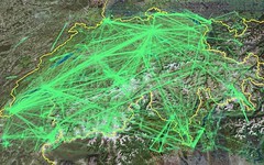
A map of Switzerland by tourists for tourists?
Scenarios based on digital footprints lefts by people in urban environments seem to rely on the structure (urban environment), the past/current usage (social, navigation, wayfinding) and the content (POI). An application should intersect these layers in a meaningful way. However, delivering a pure mirror of the reality might be hard to reach. In some cases a meaning emerges from incomplete data patched by data mining, filtering and visualization algorithms. Their choice impact the perception of the data, potentially bringing an objective angle of the content provider and modifying the behavior. This is when read/write urbanism flirts with captology (aka persuasive computing). In other words, do the traces or the algorithms used to treat them that influence the individuals/citizens? Moreover, as discussed this week with Infovis.net‘s Juan Dünsteler, information visualization struggles between educating people in reading visualization and providing relevant metaphores. Therefore, the data presented and misunderstood can impact the decision making (Visualizing Geospatial Information Uncertainty: What We Know and What We Need to Know).
Relation to my thesis: A follow-up to Inferring Spatio-Temporal Activities in Urban Spaces, seeking inspiration for an upcoming infovis.net article and in preparation of a position paper for the Urban Mixed Realities: Technologies, Theories and Frontiers workshop.
Posted: October 4th, 2007 | 1 Comment »
The other day in Geneva I stumbled on this Obey Giant sticker placed in a public bathroom. Obey Giant is a street art campaign and an experiment in phenomenology by artist Shepard Fairey. Its sole purpose is to make people question their surroundings. Even though it might not designed to question ubicomp, the experiment is extremely relevant to the discourse on seams and invisibility created by technologies. Funnily, a couple of days before in Schipol I spotted a sign highlighting the every use of the infrastructure was recorded.

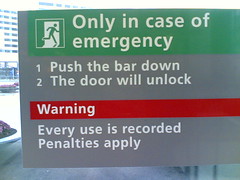
The infrastructure senses you: street art campaign (left), real-world case (right).
Relation to my thesis: Linking Andre the Giant to seamful design.
Posted: October 4th, 2007 | No Comments »
The first issue of the Journal of Location-Based Services is now online. It includes a very complete editorial lead article with A critical evaluation of location based services and their potential written by Jonathan Raper. There are several more issues of the journal queueing up to get into print, but the editors are still looking urgently for new LBS articles.
The call for paper, states a wide scope of interest:
Published research will span the field from location-based computing and next-generation interfaces through telecom location architectures to business models and the social implications of this technology. The diversity of content echoes the extended nature of the chain of players required to make location-based services a reality. Hence the journal’s aim is to bridge the research undertaken in industry and academia and promote communication amongst all in this diverse and rapidly growing sector
Relation to my thesis: a very fine place to publish.


