Posted: September 4th, 2007 | 1 Comment »
A nice follow-up of an old post on the deployment of Minicipal WI-Fi (Metro-Scale WiFi Reality Check), the Economist covers in Reality bites the troubles that now local authorities and specialist firms such as EarthLink and MetroFi. I was mentioning the mismatch between on one hand the patchy network coverage and real-world connectivity issues due to physical, technological and economical constraints and the users’ expectations on the other hand. This now proves to be the root of the problem to force some cities to abandon their utopian dreams of city-wide networks. Real-world deployments finally reveal that Wi-Fi, which relies on outdoor radio transmitters, does not provide good access inside buildings, since it uses weak signals which do not always penetrate thick exterior walls. Proponents of the technology also underestimated the number of transmitters that would be needed to provide blanket coverage. Most networks deployed between 2004 and 2006 used between 20% and 100% more nodes than expected, which pushed up costs.

My free Wi-Fi experience in Toronto. So long for the utopia…
Relation to my thesis: When Embracing the Real World’s Messiness starts to make sense.
Posted: September 1st, 2007 | No Comments »
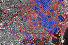
As part of the Tracing the Visitor’s Eye project, I have been toying with Processing to produce animations from the spatio-temporal data set collected from Flickr.
A first animation reveals the tourist activity in Barcelona over 2006.
 l
l
[Access visualization applet and movie]
Then, I tried to apply a skew algorithm (still not fully there yet…) to show intensity of the activity in 3D, here with the Tuscany region with the 2006 dataset.
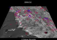
[Access visualization applet and movie]
Relation to my thesis: In addition to R, I plan to use Processing to visualize the data of a couple of my current projects. The might be the opportunity to an exploration tool for the flickr (or any other spatio-temporal) dataset by integrating Processing with the NAVA Worldwind Java SDK.
Posted: August 28th, 2007 | No Comments »
Meeting to discuss my DEA thesis. We agreed that the focal point of my research shifted from uncertainty to granularity of location information. The first is a problem to solve (while sometimes being an opportunity), the latter is a source for interaction. In my model of the social-technical gap in location aware computing, I intend to define their relations. I hypothesize that uncertainty appears when a location system does not match the granularity of information expected by a user. So I keep the work I have done so far on the reactions (uncertainty) to fluctuating location information, and focus more on the factors influencing people to tune the information. This is what I need to further investigate in my ethno study of the taxi drivers (e.g. the funnel metaphor to access information, their use of neighborhoods, landmarks, addresses). Similarly with my Flickr study I could include the analysis of the textual description (i.e. tags) to understand how the users describe the granularity (for example: city -> landmark). Results of complete studies from different contexts could already be a nice outcome to define key aspect of human interaction with location information granularity in a mobile context. It could open the door to the definition of sub-issues (psycho, social, cultural, gender, …) that would be mostly outside of the scope of my thesis. No decisions have been made on further studies (let’s see what the outcomes of the 2 current studies), but we certainly don’t lack of ideas. The concept of granularity of location information is nothing new. However, it is worth revisiting it since “we use things that did not exist previously”.
As for the DEA thesis, he shared my mixed feelings. I believe I have not achieved a good breadth-depth ratio, trying to cover too many aspects of my research domain. Then I lacked of energy to argument the choice (why a mention to privacy? -> uncertainty as opportunity + studies in spatial cloaking) and linkage of the key concepts. However, I think the breadth of this initial scope will help me in the long run. We discussed that chapter 3 (literature review) was not well self-contained. That is that I did not argue enough for the choice of the topics, the perspectives I chose to cover them, and their relevance to my work. The last section (Discussion) clearly revealed that lack of connection between the concepts described and the future work. I should rewrite that part by focusing and arguing the key elements of my framework and their relations.
Relation to my thesis: Still not quite in the narrow part of the funnel… but working on it.
Posted: August 21st, 2007 | No Comments »
Ticket machines are often the first systems tourists must interact with when they arrive in a city. They are the first interface of the city. They give that first impression of how much a visitors is expected and welcomed. Yet, some cities still fail at providing decent interfaces for tourist to get around. The Norwegian newspaper published an article on the tourists struggle with local transport in Oslo. Contrary to the content of the article, the problem does necessarily come from the language, but also on the design of the overall system such as providing spatial clues (e.g. map) of the transportation network in space or matching the name of the main stations/stops with designations collected from the surrounding attractions.
Nicolas gave examples on the bad design of Lausanne ticket machines and the better tentative in Geneva.


Ticket machines in Lausanne (left), Geneva (right). Photos courtesy of Nicolas Nova.
Relation to my thesis: One of my current project deals with enhancing the tourist experience of the city. There is a lot to learn form the confusion of tourist interacting with current systems to use a city infrastructure. It could prevent producing similar errors in the design mobile location-aware application.
Posted: August 21st, 2007 | No Comments »
Karen Martin wrote a nice piece (with great images supporting the text) on Methods for Social Computing based on Paul Dourish’s Where the Action Is. Dourish defines “social computing,” as the attempt to incorporate sociological understandings into interface design. He grounds his argumentation on the idea of embodied interaction that is the notion that physical and social phenomena unfold in real time and real space as a part of the world in which we are situated, right alongside and around us. In consequence, Dourish argues, for the now more common approach of incorporating the understandings of how social practice emerges in the design of systems to fit more easily into the ways in which we work. Karen goes on defining the the methods to support social computing mainly ethnography, ethnomethodology (ethno with “practical sociological reasoning”, that is relying on people’s understanding/knowledge of their reasons for acting) and technomethodology (use of ethnomethodology not only for critique but also for design). The evaluation of the design should rely on similar contextualized methods out of the sterile confines of a laboratory. As Dourish concludes, “the only way to come to a good understanding of the effectiveness of a software system is to understand how it features as part and parcel of a set of working practices, as embodied by a group of people actually using the system to do real work in real working settings”. As Karen mentions, this critique remains at the core of discussion on the validity of HCI studies.
Relation to my thesis: Over the summer I read Andy Crabtree’s Designing Collaborative Systems : A Practical Guide to Ethnography that helped me setup my study of taxi drivers. It completes the more theoretical content of Where the Action Is.
Posted: August 21st, 2007 | No Comments »
Jonathan Raper uploaded an extensive bibliography of research in Location-Based Services (MobilityNewv2.txt) that mirrors the one in the Editorial Lead article of the upcoming first issue of the Journal of Location-Based Services.
Relation to my thesis: A complement to my current bibliography (in BibTeX).
Posted: August 20th, 2007 | No Comments »
As part of the Cityware Project in Bath, UK, Vassilis Kostakos released a Bluetooth application that links proximity data from the physical space (mobility traces) with the online network of Facebook. It aims at exploring how your real world and online social networks are intertwined. Whereas it has some similarities with Nathan Eagle’s Reality Mining, here the spatial traces are enhanced by the large amount of information disclosed on the web. The BBC has a piece on it: Bluetooth helps Facebook friends. The application is available at http://apps.facebook.com/cityware.
Relation to my thesis: The linking of online social networking and mobility traces, goes in the same direction as what I have been working on with Flickr and what could be done with iFind.
Posted: August 2nd, 2007 | 1 Comment »
The outcome of the work performed during this Spring’s stay at the MIT has been accepted for full presentation at the 4th International Symposium on LBS and Telecartography, November 8-10, 2007 in Hong Kong. The paper is entitled “Understanding of Tourist Dynamics from Explicitly Disclosed Location Information” by Fabien Girardin, Filippo Dal Fiore, Josep Blat, and Carlo Ratti
Abstract: In the recent years, the large deployment of mobile devices led to a massive increase in the volume of records of where people have been and when they were there. The analysis of the accumulated archives of such spatio-temporal data can derive high-level human behavior information valuable to urban planers, traffic engineers, and tourism authorities. In this paper, we describe our approach to analyze the history of physical presence of tourists from the digital footprints they publicly make available on the world-wide web. Our work takes context in the Province of Florence where besides data from survey-based hotel and museums frequentation, tourism authorities have limited information on the fluxes of visitors (i.e. previous and next destination) and on the nationalities of the tourists who do not sleep in town (i.e. excursionists). As a proof of concept, we used a corpus of 85910 publicly disclosed geotagged photos taken in the province by 3348 photographers over a period of 2 years. Based on the time, explicit location and people’s description of their photos, we design geovisualizations to reveal the tourist activity and flows in space and time. They provide insights on the density of tourists in the area the flow and activity of tourists within, in and on of that area.
Keywords: Spatio-temporal data analysis, geovisualization, location-disclosure, location-based services.
Relation to my thesis: Tracing the Visitor’s Eye is off to a good start. Plus now there is a shot to get the paper accepted in an upcoming book on Location-Based Services and Telecartography. Finally, this conf might be the opportunity to meet Jonathan Raper who will keynote.
Posted: July 31st, 2007 | No Comments »
It is called “Towards Reducing the Social-Technical Gap in Location-Aware Computing” and the abstract goes as follow:
Abstract: Along in their history, humans never ceased to create techniques and tools for observing their environment and locate themselves in the physical environment. This attests our necessity to be aware of who and what is where and when – a concept that we term location awareness. Nowadays, the democratization of mobile and wireless technologies increases people’s awareness of their whereabouts. However, it also their interaction with the physical environment and by consequence impacts the social interactions and work practices.
Building ubiquitous applications that exploit location requires integrating underlying infrastructure for linking sensors with high-level representation of the measured space to support human activities. However, the real world constraints limit the efficiency of location technologies. The inherent spatial uncertainty embedded in mobile and location systems constantly challenges the coexistence of digital and physical spaces. Consequently, the technical mechanisms fail to match the highly flexible, nuanced, and contextual human spatial activities. These discrepancies generate a social-technical gap between what should be socially supported and what can be technically achieved. This thesis contributes to the research in the field of Computer Supported Cooperative Work (CSCW) and ubiquitous computing by exploring, and hopefully reducing this gap in the context of location-aware systems.
Our preliminary work reports on complementary studies of some of the aspects of the social-technical gap. This preliminary and current work, takes very different perspectives on the use of location-aware applications. These views highlight the role of the spatial context and technological limitations in the use of the systems features. First, we explored the impact of the technical limitations in collaborative tasks experienced in the form of a location-aware game. It allowed us to define the sources of spatial uncertainty perceived by the users while interacting with the system. Then, we investigated the social requirements of linking information to space. In particular, we report on the influence of space in the use of location granularity to share and retrieve photos. Finally, we describe an ongoing ethnographic study of the evolution of taxi drivers practices with the introduction of location-aware and navigation systems in their work. This work reveals the ways positioning technologies influence the work practice of mobile workers. For instance, some drivers access the geospatial information as in a “funnel”. They start a ride with a general idea of an area surrounding the destination. As they enter the targeted area they access detailed information for the specific destination with location-aware application.
The extensive review of the domains of ubiquitous computing and CSCW shows that more of the research in those fields focus on optimizing the accuracy of location sensing and providing seamless interaction. On the other hand, limited work has been pursued to understand the social-technical issued in real-word settings and provide solutions to match the visions of supporting people’s everyday life activities. In consequence, we suggest research perspectives that should contribute to this agenda. Through real-world field studies, we aim at providing solutions for the design of collaborative location-aware systems that take into account the spatial uncertainty inherent to ubiquitous technologies.
Keywords: location-aware computing, spatial uncertainty, CSCW, location-awareness.
Relation to thesis: More than half-way through the PhD… I hope.
Posted: July 26th, 2007 | No Comments »
7.5th Floor now takes part of the newly created LIFT lab’s “/think” publication platform. The idea launched by Laurent Haug is to join the forces of people writing, reporting and thinking on technology and society and put them under the LIFT lab umbrella. LIFT lab is a network-based company that provides among other things, the LIFT series of events, consulting services and publications. Other blogs are gathered under this umbrella with Nicolas’ Pasta &Vinegar as flagship.
7.5th Floor will remain dedicated to reporting my readings, thoughts and milestones as part of my PhD thesis on the socio-technical gap in ubiquitous location-aware computing.
Many thanks to Luc (to whom I owe several diners in his favourite Zürich restaurants) for hosting this bazar from the beginning.